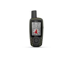
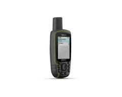
Garmin GPSMap 66SR Multiband


NAVIGATE YOUR NEXT ADVENTURE
Whether you’re hiking, hunting, climbing, geocaching, kayaking or mountain biking, explore more by using this premium, rugged handheld with a 3-inch colour display, preloaded maps and optimal accuracy.
No squinting necessary with this large, sunlight-readable colour display.
Multi-band technology and expanded GNSS satellite support guide the way in challenging locations.
Maps as pretty as a picture and just as detailed — without a subscription.
See the peaks and valleys clearly with TopoActive Europe maps.
Having Active Weather is like having your own personal weather forecaster on your journey1.
Explore more with up to 36 hours of battery life in GPS mode and up to 450 hours in Expedition mode.
EXPANDED GNSS SUPPORT
Multi-band technology and expanded GNSS support (GPS, GLONASS, Galileo, QZSS and IRNSS) provide optimal accuracy in steep country, urban canyons and forests with dense trees.
ABC SENSORS
Navigate every trail with ABC sensors, including an altimeter for elevation data, barometer to monitor weather and 3-axis electronic compass.
BIRDSEYE SATELLITE IMAGERY
Download high-resolution photo-realistic maps directly to your device without an annual subscription. Easily find trails, pick stand locations, find parking, create waypoints and more.
PRELOADED TOPOACTIVE MAPS
Preloaded TopoActive maps provide detailed views of routable street and off-road networks, waterways, natural features, land use areas, buildings and more.
ACTIVE WEATHER
When paired with your compatible smartphone, you can get real-time forecast information and live weather radar, so you’re aware of the surrounding conditions1.
BUILT FOR ADVENTURE
This handheld is built to military standards for thermal, shock and water performance (MIL-STD-810), and it’s even compatible with night vision goggles.
LED FLASHLIGHT
The GPSMAP 66 series helps you keep gear to a minimum with a built-in LED flashlight that can be used as a beacon to signal for help.
GEOCACHING
Get automatic cache updates from Geocaching Live, including descriptions, logs and hints. When connected via Wi-Fi® technology or to the Garmin Connect™ app2, each find will upload to your Geocaching.com profile.
GARMIN EXPLORE™ APP
Plan, review and sync waypoints, routes and tracks by using the Garmin Explore™ app2 and website. You can even review completed activities while still in the field.
BATTERY LIFE
Internal Lithium-ion rechargeable battery provides up to 36 hours of battery life in GPS mode and up to 3 weeks in Expedition mode.
PHYSICAL DIMENSIONS 6.2 x 16.3 x 3.5 cm
DISPLAY SIZE 3.8 x 6.3 cm; 3-inch diagonal (7.6 cm)
DISPLAY RESOLUTION 240 x 400 pixels
DISPLAY TYPE Transflective, colour TFT
WEIGHT 230 g with batteries
BATTERY TYPE Rechargeable, internal lithium-ion
BATTERY LIFE Up to 36 hours, up to 450 hours in expedition mode
WATER RATING IPX7
MIL-STD-810 yes (thermal, shock, water)
HIGH-SENSITIVITY RECEIVER
INTERFACE High-speed micro USB and NMEA 0183 compatible
MEMORY/HISTORY 16 GB (user space varies based on included mapping)
In the box:
GPSMAP 66sr
USB cable
Carabiner clip
Documentation
- Visa
- Mastercard
- American Express
- Visa Debit
- Bank Deposit
Related Products
 Sale
Sale
 Sale
Sale