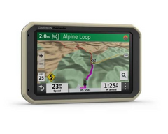
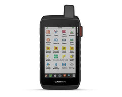
Garmin Overlander GPS AUS/NZ
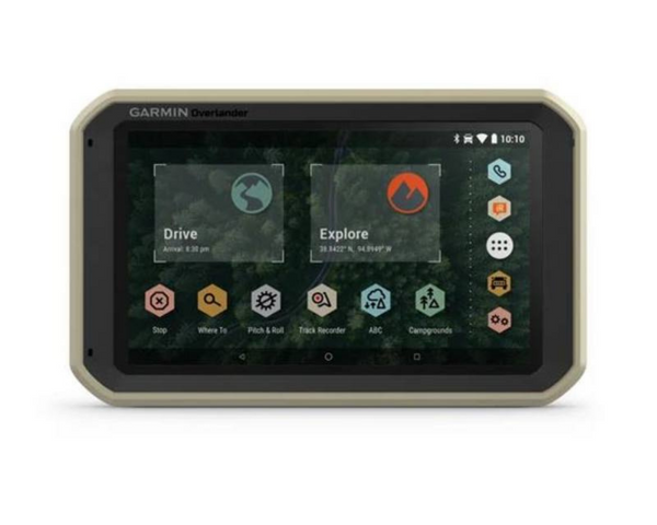


ROAM THE UNKNOWN
Built for every part of the journey, Overlander is the rugged, all-terrain navigator with on- and off-road navigation.
Get the lay of the land with topographic maps for Australia and New Zealand.
Or get spoken directions to the nearest coffee shop with street maps.
Share1 the plans for adventure through Garmin Explore. From your laptop to your phone to your friends.
Comes with a powered magnetic mount and a RAM ball mount. It’s not going anywhere.
Search for the nearest inspiration point while you’re in the middle of nowhere.
Need to bring your own satellite imagery? How does 64 GB of built-in storage sound?
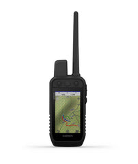
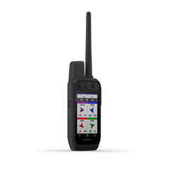
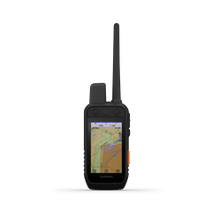
ON AND OFF ROAD
7” colour touchscreen features turn-by-turn directions for on-road and off-road navigation covering Australia and New Zealand. Includes 64 GB internal memory to download additional TOPO maps
MILITARY STANDARD 810
Overlander is built to the U.S. military standard 810 for thermal and shock resistance. It can be mounted anywhere, thanks to the powered magnetic mount that comes with suction cup and 1” RAM ball compatible adapter.
IP5X DUST RATING
This essential piece of overlanding gear is purpose-built from the circuit board up and is designed to withstand dust and extreme temperatures.
GARMIN EXPLORE
Use the Garmin Explore app to download additional maps – such as satellite imagery and USGS quad sheets on 64 GB of internal storage – and sync all your data between devices. Easily import and export GPX files to Garmin Explore — even if offline.
FIND CAMPSITES
Overlander is preloaded with iOverlander POIs and Ultimate Public Campgrounds, so you don’t need a cell signal to route to the best-established, wild and dispersed campsites.
FIND BOUNDARIES
Overlander features preloaded topography for Australia and New Zealand. Download additional topographic maps worldwide on the 64 GB of internal storage.
KNOW YOUR VEHICLE
Customize street navigation for the size and weight of your overlanding vehicle, plus get alerts for upcoming bridge heights, weight limits, sharp curves, steep grades and more.
MULTI-GNSS SUPPORT
GPS, GLONASS and Galileo support helps track in more challenging environments than GPS alone.
NAVIGATION TOOLS
All of your overlanding equipment – such as a built-in compass, altimeter and barometer – is now in one device.TRACK RECORDER
Record your tracks, and save them to your Garmin Explore account so you can review them later on any device or share them with friends.
PITCH AND ROLL
Overlander comes with integrated pitch and roll angles to help you and your vehicle navigate difficult terrain.
INREACH® COMPATIBLE
Pair your Overlander navigator with the inReach Explorer®+, inReach SE®+ and inReach® Mini satellite communicators2 (sold separately) for two-way text messaging, interactive SOS and weather forecasts.
BACKUP CAMERA COMPATIBLE
Pair your Overlander with up to 4 of our BC™ 35 wireless backup cameras (sold separately) so you can see what’s behind you.
PHYSICAL DIMENSIONS W x H x D 19.9 x 12.2 x 2.4 cm
DISPLAY SIZE W x H 15.2 x 8.9 cm; 7" diagonal
DISPLAY RESOLUTION 1024 x 600 pixels
DISPLAY TYPE Multi-touch, glass, WSVGA colour TFT with white backlight
WEIGHT 437 g
BATTERY TYPE Rechargeable lithium-ion
BATTERY LIFE Up to 3 hours
DROP RATING MIL-STD-810
DUST RATING IP5X
- Visa
- Mastercard
- American Express
- Visa Debit
- Bank Deposit
Related Products
 Sale
Sale
 Sale
Sale
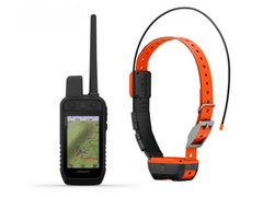
Garmin Bundle Alpha 200 GPS/T20 Dog Collar
Garmin Bundle Alpha 200 GPS/T20 Dog Collar Combo Package
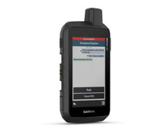
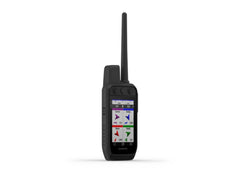
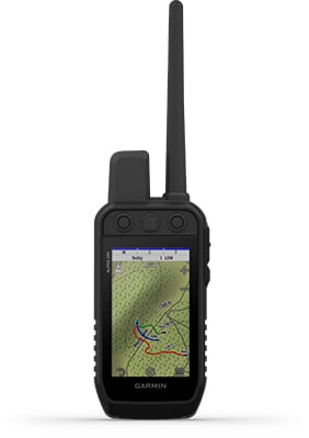
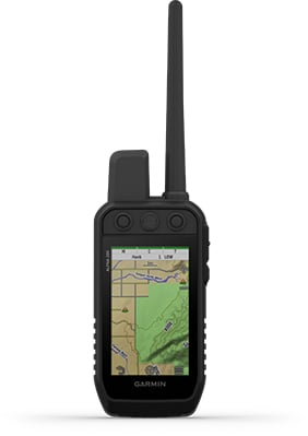
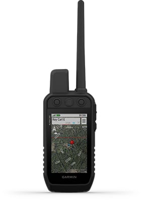
STRONG CONNECTION. STRONG BOND. Track and train your dogs with the Alpha 200, Handheld Only system, a sunlight-readable 3.50" capacitive touchscreen and user-friendly, six-button design.
Key Features:
• This handheld is designed to help make tracking and training simple, accessible and fast.
• Track and train your pack while they’re out in the field.
• Keep inactive dogs in the system for easier setup and management.
• Navigate every hunt with the best in Garmin mapping and sensors.
• User-replaceable battery lasts up to 20 hours.
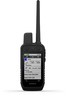
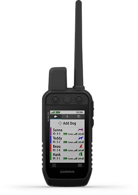
TRACK YOUR PACK. Monitor up to 20 dogs from up to 14.50 kilometres (depending on dog device) with a 2.50-second update rate.
DOG LIST/GROUP MANAGEMENT. Keep inactive dogs in your dog list, and manage active groups so you don’t have to add and remove dogs for every hunt.
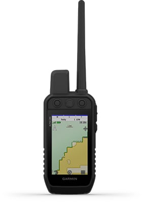
PUBLIC LAND BOUNDARIES. Optional display of public land boundaries on topographical maps helps you know that you’re venturing where you’re supposed to be.
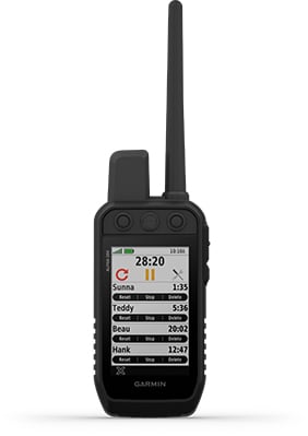
HUNT METRICS. See each dog’s daily hunting patterns, distance and speed so you can monitor performance and help prevent overheating. Pair with TT™ 15 tracking and training collars.

SIX-BUTTON DESIGN. Use dedicated buttons for fast training cues and minor adjustments in the field.
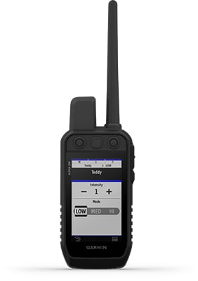
18 LEVELS OF STIMULATION. Momentary and continuous stimulation options let you customise training for each dog.
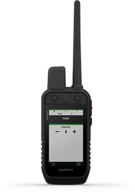
TONE/VIBRATION. Issue different levels of audible tone or vibration commands for quick adjustments to individual dogs.
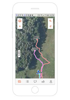
GARMIN EXPLORE™ APP. Pair with the Garmin Explore app on your compatible smartphone to see real-time dog tracking information, save collections of dog tracks and replay tracks to see exactly what happened during your hunt.
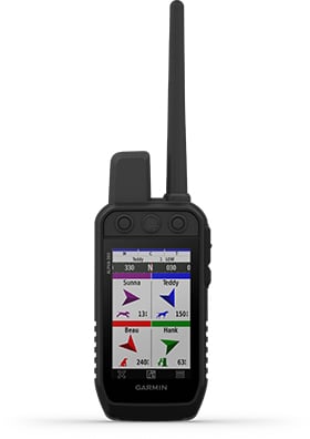
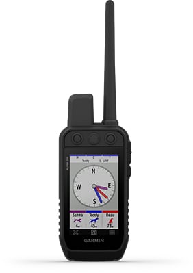
PRO VIEW COMPASS. The pro view compass mode gives you simple, at-a-glance tracking that shows which direction and how far away your dogs are, plus you will see when a dog is “Treed” or “OnPoint.”
MULTI-GNSS SUPPORT. Access multiple global navigation satellite systems (GPS and Galileo) to track your pack with greater accuracy than GPS alone.
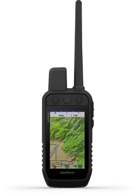
TOPOACTIVE MAPS. Our preloaded TopoActive mapping provides detailed views of terrain contours, topographic elevations, summits, parks, coastlines, rivers, lakes and geographical points.
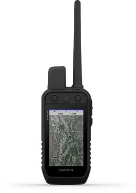
BIRDSEYE DIRECT. Download BirdsEye Satellite Imagery directly to the handheld for better-than-real-life views of your route, trailheads, clearings and more.
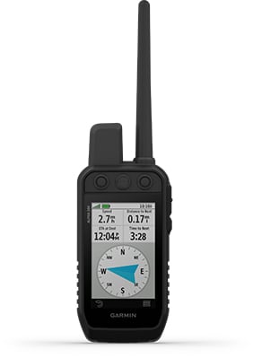
NAVIGATION SENSORS. A barometric altimeter helps you accurately monitor ascent and descent and see short-term trends in air pressure, and the built-in tilt-compensated 3-axis electronic compass keeps your bearing - whether you’re moving or not.
SEE IT ALL. The sunlight-readable 3.50? capacitive touchscreen display makes it easy to see and interact with your maps, dog data and more — even while wearing gloves.
STAY ON THE MOVE. Replaceable battery lasts up to 20 hours, giving you plenty of hunt time with your dogs in the field.
ADDITIONAL MAPPING. The microSD™ card slot allows you to load more mapping options, such as TOPO Australia and New Zealand Light and HuntView maps (each sold separately).
Specifications:
General
• PHYSICAL DIMENSIONS: 7.70 x 6.40 x 1.30? (6.80 x 16.20 x 3.40 cm) *dimensions do not include antenna
• TOUCHSCREEN: Yes
• DISPLAY SIZE: 1.80? W x 3.0? H (4.70 x 7.70 cm); 3.50? diag (88.90 mm)
• DISPLAY RESOLUTION: 282 x 470 pixels
• DISPLAY TYPE: Transflective, colour TFT touchscreen
• WEIGHT: 9.90 oz (280 g) with standard antenna and battery
• BATTERY TYPE: Rechargeable lithium-ion (included)
• BATTERY LIFE: Up to 20 hours
• WATER RATING: IPX7
• HIGH-SENSITIVITY RECEIVER: Yes
• INTERFACE: High-speed USB
• MEMORY/HISTORY: 16 GB
• PRODUCT NUMBER: 010-02616-53
Maps & Memory
• PRELOADED MAPS: Yes (TopoActive)
• ABILITY TO ADD MAPS: Yes
• BASEMAP: Yes
• AUTOMATIC ROUTING (TURN BY TURN ROUTING ON ROADS) FOR OUTDOOR ACTIVITIES: Yes (with optional mapping for detailed roads)
• BIRDSEYE: Yes, direct to device (no annual subscription required)
• EXTERNAL MEMORY STORAGE: microSD™ card (not included)
• WAYPOINTS/FAVORITES/LOCATIONS: 10,000
• TRACKS: Up to 20 dogs (TT 15/TT 15 mini and T5/T5 mini) and buddies (Alpha 100 and Alpha 200) simultaneously
• TRACK LOG: 20,000 points, 200 saved gpx tracks, 300 saved fit activities
• ROUTES: 250
• STORED CONTACTS: 250 dogs
• GROUP MANAGEMENT: Yes
Sensors
• BAROMETRIC ALTIMETER: Yes
• COMPASS: Yes (tilt-compensated 3-axis)
Outdoor Recreation
• SUN AND MOON INFORMATION: Yes
• CUSTOM MAPS COMPATIBLE: Yes
Two-way Radio Features
• FREQUENCY BAND: MURS
• RANGE: TT 15/T5, 14.50 kilometres; TT 15 mini/T mini, 14.50 kilometres
Outdoor Applications
• COMPATIBLE WITH GARMIN EXPLORE™ APP: Yes
• GARMIN EXPLORE WEBSITE COMPATIBLE: Yes
Connections
• WIRELESS CONNECTIVITY: Yes (Wi-Fi®, Bluetooth® and ANT+®)
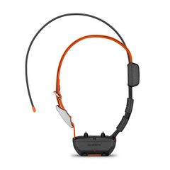
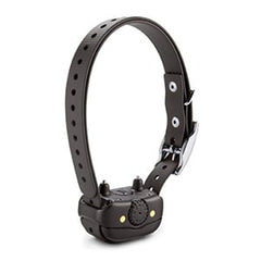
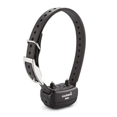
Garmin T20 - TRACK YOUR PACK.
No matter what kind of dogs you run or how you hunt, Garmin Alpha® T 20 is the slim, rugged and universally sized collar designed to help you build a better dog — no matter the breed.
Key Features:
- Track your dog up to 14.5 kilometers when used with a compatible handheld (sold separately)
- Optimise your battery life with dynamic tracking
- Collar is universally sized to fit large and small breeds
- Easily change the user-replaceable flex band
- Uses multicolour location beacon for low-light conditions
- Get automatic software updates when charging and connected to your network with Wi-Fi® technology
TRACKING
The top-mounted, high-sensitivity GPS and Galileo receiver keeps track of your dog’s location, and the Alpha® T 20 collar transmits that location via VHF up to 14.5 kilometers away with updates as frequent as every 2.5 seconds when used with a compatible handheld (sold separately).
UNIVERSAL SIZING
A rugged yet slim design is universally sized to fit large and small breeds.
DYNAMIC TRACKING
Get extended battery life with dynamic tracking based on your dog’s movement.
RUGGED DESIGN
The collar features a user-replaceable flex band that can withstand the toughest outdoor environments.
LED BEACON LIGHTS
This collar features bright, multicolour LED beacon lights to help you identify and track your dog in low-light conditions. They can be remotely activated and changed from a compatible handheld (sold separately).
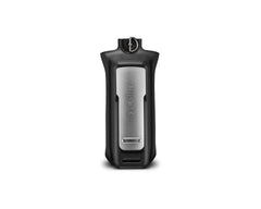
REPLACEABLE BATTERY PACKS
When using dynamic tracking, get up to 68 hours with the standard battery pack and up to 136 with the extended battery pack (sold separately).
AUTOMATIC UPDATES
Receive automatic software updates when Alpha® T 20 is charging and connected to your network with Wi-Fi technology.
PAIR WITH HANDHELDS
The Alpha® T 20 GPS dog collar easily pairs with Garmin dog tracking handhelds, such as the Alpha® series (sold separately).
Specifications:
- Unit dimensions (WxHxD): 8.1 x 4.5 x 3.5 cm (3.2? x 1.8? x 1.4?)
- Weight: 168.5 g (5.9 oz) for transmitter and antenna (without collar), 239.5 g (8.4 oz) total weight (with collar)
- Battery type: Rechargeable lithium-ion pack; user-replaceable
- Battery life: Standard battery pack (included) - up to 68 hours using dynamic tracking (default), up to 25 hours with location updates every 2.5 seconds, up to 84 hours with location updates every 2 minutes, Extended battery pack (sold separately), up to 136 hours using dynamic tracking (default), up to 50 hours with location updates every 2.5 seconds, up to 168 hours with location updates every 2 minutes
- Range: 14.5
- Interface: USB-C
- Water rating: 1 ATM (10 metres)
- Neck size: With standard 1? collar strap: minimum of 9.5? (24 cm) in circumference, With flipped 1? collar strap: minimum of 6.5? (16.5 cm) in circumference
- High-sensitivity GPS/Galileo receiver: Yes
- GPS antenna: Top-mounted, orange
- Vibration/Tone: Not available in the U.S.; may be available in other regions
- LED beacon lights: Yes (multiple colour options)
- Flex band: User-replaceable
- Sleep mode: Yes (Alpha® Series only)
- Rescue mode: Yes
- Frequency mode: VHF
- Replaceable collar straps: Yes
- Collar compatibility: Up to 1? (2.54 cm)
- Automatic software updates: Wi-Fi® technology (when charging and connected to a network)
- Manufacturer code: 010-02447-03
 Sale
Sale