


 New
New
Swazi Doughroaster Long Sleeve Fleece Top - Tussock
Swazi Doughroaster Long Sleeve Fleece Top - Tussock
“Doughroaster” is Kiwi hunting slang for whoever stays in camp for a lay-day, to clean trophies or fish and above all, sort out dinner.
Hence the Doughroaster – a midweight fleece jumper for easy days or packing on the hill against morning or evening chill. Works well as a mid-layer, or an outer layer on milder days.
We’re guessing yours will see just as much use around town as it does on the hunt.
Features
- 280gsm polar fleece
- Long chest zip lets you dump or trap heat fast
- High collar to keep the wind off your neck
- Large zippered kangaroo pocket to save your keys and phone
- Adjustable hem pull cord
Specifications
- Fabric: 280gsm Polar Fleece - You've not worn a decent fleece garment until you have tried one of Swazi's fleece garments. Unlike other brands of fleece, Swazi's 280gsm high-quality, plush fleece is built tough but comfy. No scratchy, squeaky fleece hear, it's quality all the way.
- Layer: Outer Layer - A stylish and practical outer layer, or pair it with a rain jacket for all weather protection.
- Conditions: Mild / Cold / Dry - Super tough for outdoors work on the farm, a great addition to your next hunt, on the sidelines or around the campfire.
- Function: Breathable - Breathable to let the sweat out.
- Weight: Size Large - 600 grams / 1.32 lbs
 New
New
Swazi Forest 2 Trouser Green
Swazi Forest 2 Trouser Green
3 years testing on 4 continents. To say the Forest Pants are a well thought out garment is quite the understatement. Built as a hard working performance pant from our new rugged 4-way stretch Venator fabric, these pants mean business. The slightly slimmer fit wears in like your favourite pair of jeans, relaxing and molding to your body after just a few adventures.
These pants are a slim fit, we suggest you size up from your normal jeans size. Multiple pockets (including thigh vented ones), articulated knees, removable knee pads, sturdy dry bum backside and weather resistant fabric elevate the Swazi Forest Pants from everyday workwear to kickass adventurer. Great looking garments with superb performance mean this range is so stylish and so comfortable you will want to wear it all of the time.
Made from a highly sustainable product.
Features
- Slim fit that moulds to your body after just a few wears
- Built in 4 way stretch provides amazing comfort and freedom of movement
- Water and mud-resistant
- 2 deep zippered side pockets
- 1 back pocket
- 2 vented thigh pockets
- Zippered and domed fly
- Reinforced, water resistant backside with fluffy interior
- Articulated knees
- Knee pads (insert pocket inside the leg)
- D-ring for keys, carabiner etc
Specifications
- Fabric: Swazi's new Ventor Fabric. Venator fabric is, quite simply, incredible! A superb blend of Nylon/Polyester/Spandex fabric with great stretch, warmth and durability, it offers outdoors people a new take on comfort and performance. Lightly brushed on the inside for extra comfort and warmth.
- Layer: Outer Layer. The outer layer, or shell as it is sometimes known, has a big job to do. It is your best form of defense against wind, showers and snow. Choose a garment that will do all of the above, not just by fabric, but by DESIGN!
- Function: Weather resistant - Venator fabric offers water repellent 4 way nylon stretch. Breathable - There's no point in wearing something that keeps out the rain if it keeps in the sweat - you still get wet.
- Conditions: Cold/Mild/Warm. A super tough performer in all types of environment.
 New
New
Swazi Forest Trousers 2 Tussock
Swazi Forest 2 Trouser Tussock
3 years testing on 4 continents. To say the Forest Pants are a well thought out garment is quite the understatement. Built as a hard working performance pant from our new rugged 4-way stretch Venator fabric, these pants mean business. The slightly slimmer fit wears in like your favourite pair of jeans, relaxing and molding to your body after just a few adventures.
These pants are a slim fit, we suggest you size up from your normal jeans size. Multiple pockets (including thigh vented ones), articulated knees, removable knee pads, sturdy dry bum backside and weather resistant fabric elevate the Swazi Forest Pants from everyday workwear to kickass adventurer. Great looking garments with superb performance mean this range is so stylish and so comfortable you will want to wear it all of the time.
The Swazi Forest Pants 2 are the same as the original Forest Pants, just with a change in the fit of the thighs and the knee pad area is now externally accessible.
Made from a highly sustainable product.
Features
- Slim fit that molds to your body after just a few wears
- Built in 4 way stretch provides amazing comfort and freedom of movement
- Water and mud-resistant
- 2 deep zippered side pockets
- 1 back pocket
- 2 vented thigh pockets
- Zippered and domed fly
- Reinforced, water resistant backside with fluffy interior
- Articulated knees
- Knee pads (insert pocket inside the leg)
- D-ring for keys, carabiner etc
Specifications
- Fabric: Swazi's new Ventor Fabric. Venator fabric is, quite simply, incredible! A superb blend of Nylon/Polyester/Spandex fabric with great stretch, warmth and durability, it offers outdoors people a new take on comfort and performance. Lightly brushed on the inside for extra comfort and warmth.
- Layer: Outer Layer. The outer layer, or shell as it is sometimes known, has a big job to do. It is your best form of defense against wind, showers and snow. Choose a garment that will do all of the above, not just by fabric, but by DESIGN!
- Function: Weather resistant - Venator fabric offers water repellent 4 way nylon stretch. Breathable - There's no point in wearing something that keeps out the rain if it keeps in the sweat - you still get wet.
- Conditions: Cold/Mild/Warm. A super tough performer in all types of environment.
 New
New
Swazi Ibex Jacket Waterproof & Windproof Olive
Swazi Ibex Jacket Waterproof & Windproof Olive
It’s seems everyone loves the Kagoule but they want a full-zip, so here it is! No fancy pitch here, just giving the people what they ask for – the Swazi way. The Ibex Jacket is made from a 3-layer AEGIS knit fabric which is soft, light, very quiet and of course, very waterproof. With AEGIS Wstershield for total wind and water proctection, the enhanced breathability of AEGIS allows moisture vapour (perspiration) to escape your clothing system, so you ared dry, snug and able to perform at peak levels.
The Whisper fabric is made from a bushed polyester tricot knit and coated in a eco-friendly DWR.
Features:
- Made from the ultra quiet AEGIS® 3-layer Whisper fabric, with a full length YKK® zip opening. 100% windproof, waterproof, breathable
- Brushed outer layer makes the coat quiet to avoid startling animals
- Chest pocket with riveted radio antenna easement channelled through the rubber chest label
- Legendary Swazi high periphery vision hood
- Adjustable waist cord with scalloped tail
- Water-resistant YKK® zips
- New pit-zips!
- Two front pockets
- Adjustable wrist cuffs
- Waterproof rating up to to 20,000mm H2O
- Breathability rating up to 20,000g/m2/24hrs
Specifications:
- Fabric – Ultra quiet AEGIS® 3-layer Whisper fabric
- Layer: Outer layer
- Function: Waterproof, windproof, breathable
- Conditions: Wet / windy
- Weight (Size L) = 800g/0.7lbs
- Colour: Olive
- Sizes: Medium - XX Large

 New
New
Olight Battery Cell for Javelot Turbo 2
Olight Battery Cell for Javelot Turbo 2
Keep your Javelot Turbo 2 performing at its best with this dedicated replacement battery pack. Designed specifically for a perfect fit and reliable power delivery, it’s ideal as a backup or a replacement for extended use in the field. Simple to swap and built to last, this battery pack ensures your light is always ready when you need it most.
Specifications for Olight Battery Cell for Javelot Turbo 2:
- Compatibility: Olight Javelot Turbo 2
- Battery Pack Only

 New
New
Olight Warrior X 4 Tactical Flashlight 2600 Lumens 630m Beam Distance
Olight Warrior X 4 Tactical Flashlight 2600 Lumens 630m Beam Distance
Defy The Darkness
Featuring max 2,600lm output and 630m beam distance, the X4 balances the spot and spill well with a peak beam intensity of 99,310 candela, and is equipped with a dazzling strobe, making it born for warriors.
2 Recharging Options + 3-Color Indicator
It can now support both USB-C and MCC3 recharging, IPX8 waterproof rating remains even with the port exposed. A three-color indicator is added, with still vibration prompt to better show the battery life.
Portable Holster
Use the safe and convenient holster to unlock more storing and carrying methods.
Strikingly Impressive Looking
The Warrior X 4 exudes a commanding presence with its concise yet powerful design. The eye-catching harpoon-like logos on the head and tail further enhance its aggressive aesthetic, giving the impression that this tactical companion is ready to conquer any darkness that lies ahead.
Carefree Dust Cover
The battery indicator and the USB-C interface are hidden behind a dust cover -- let them appear by rotating it a quarter.
Specifications for Olight Warrior X 4 Tactical Flashlight 2600 Lumens 630m Beam Distance:
- Max Output: 2,600 Lumens
- Max Throw: 2,066 ft
- Max Light Intensity: 99,310 Candela
- Strobe Mode: Yes
- Tail Switch: Enlarged magnetic tail switch with nano molding tech
- Charging: MCC, USB-C
- Battery Indicator: Tri-colour battery indicator, vibrating battery indicator
- Holster: Nylon reinforced holster
- IPX8 Waterproof
- Type III hard anodized finish
- Aerospace-grade aluminum alloy
Light Settings for Olight Warrior X 4 Tactical Flashlight:
Regular Mode
- Low
- High
Tactical Mode
- Medium Mode
- Strobe Mode
 New
New
Guide TN450 2.0 Thermal Binoculars 50mm 50Hz Laser Range Finder
Guide TN450 2.0 Thermal Binoculars 50mm 50Hz Laser Range Finder
The all-new Handheld Binocular Series (TN 2.0, TN Muo 2.0, DN 2.0, and DN Muo 2.0) redefines all-weather optical imaging solutions with innovation and precision. Whether for hunting, law enforcement, or professional use, the series combines advanced thermal and visible light imaging technology, intelligent sensor fusion, and high-performance design to deliver exceptional performance and reliability, making it your ideal choice.
Brand New Housing Slim Body
The TN 2.0 Series features a slim, aesthetic housing inspired by classic binocular design, ensuring a more comfortable grip and improved handling. Compared to the previous generation, it is 20% lighter for enhanced portability.
One-Handed Focusing Simple Silent Operation
The minimalist, silent button layout features multi-functional rotary knobs and customizable buttons, greatly simplifying operation. Paired with an updated intuitive UI, you simply scroll to select and click to confirm.
Flexible Charging Unlimited Runtime
The new dual battery system brings a versatile charging solution: the built-in battery supports 18-watt fast charging, reaching 80% charge in just one hour. The replaceable standard 18650 battery supports hot swapping during operation, ensuring uninterrupted use.
Laser Rangefinder Precision Targeting
The TN 2.0 Series integrates a 1500m laser rangefinder, GPS, digital compass and gyroscope - delivering pinpoint accuracy for target location in the field.
Premium Visuals Algorithm-Optimized
The TN 2.0 Series utilizes a high-sensitivity detector with a 1920×1080 AMOLED display delivers razor-sharp clarity—further enhanced by the proprietary Hyper-light algorithm.
Specifications for Guide TN450 2.0 Thermal Binoculars 50mm 50Hz Laser Range Finder:
Sensor
- Type: Uncooled VOx Infrared Detector, 8 to 14µm
- Resolution: 400×300@12µm
- NETD: 20mK
- Frame rate: 50Hz
Lens
- Objective lens: 50mm, F1.0
- Field of view: 5.2°×3.1°
- FOV m@100m: 9×5
- Magnification: 6.2x~24.8x
- Detection range: 2600m/2800yd
- Focus: Manual
Display
- Display type: 0.49'' AMOLED 1920×1080
- Color palettes: White Hot, Black Hot, Red Hot, Green Hot, Iron Red, Blue Hot, Sepia
- Eyepiece: Eye relief: 20mm; Diopter: -6 to +6; Interpupillary distance adjustment: 58~72mm; Zoom: 13.8x
Hardware
- Laser rangefinder: 1500m/1630yd
- WIFI: 2.4G, 5G
- Interface: USB-C (Support charging)
- Others: Microphone, Compass, Gyroscope, Bluetooth
System
- Recording function: Photo/Video (Audio recording included)
- Memory capacity: 64GB
Power
- Battery type: Customized Battery (Built-in) and 18650 ×1 Battery (External)
- Operating time: 8 hours
Environmental
- Operating temp: -20°C to 50°C / -4°F to +122°F
- Encapsulation: IP67
Physical
- Weight (g/oz): 722/25.47
- Size (mm/in): 208×137×68.5/8.2×5.39×2.69
- Standard: Device, Eye Mask, Neck Strap, Carry Bag, 18650 Battery ×1, Battery Charger, 5V 2A Adapter (US or UK or Australia or Europe), USB-A to USB-C Cable, Quick Start Guide, Warranty Card
- Optional: Bluetooth Remote Control, 18650 Battery

 New
New
Guide TD653L 50mm 640x512 Hand Held Monocular Thermal
Guide TD653L 50mm 640x512 Hand Held Monocular Thermal
The TD Gen3 LRF Series handheld thermal imaging monocular innovatively integrates a laser rangefinder while maintaining a compact design. The focusing roller allows for convenient one-handed operation, while the symmetrical ergonomic design enables flexible handling with either hand. With an impressive 12-hour battery life and IP67, it is well-equipped to handle various outdoor challenges. Featuring Wi-Fi connection, it enhances the efficiency and enjoyment of your exploration.
High-Sensitivity Detector, NETD Down to 20mk
The TD Gen3 LRF Series features 12µm infrared detector with 640×512 and 400×300 resolutions, and offers optional 19mm, 25mm, 35mm and 50mm lenses, delivering impressively crisp images even in complete darkness.
Ambidextrous Design, One Handed Operation
The symmetrical housing design allows for easy operation with both left and right hands. Its button layout is ergonomically crafted to suit user habits, enabling one-handed operation.
Fine-Tuning Focus, Scroll with Fingers
The mini focusing roller design offers a unique experience of fast and precise fine-tuning, allowing users to adjust the focus with a simple scroll of one finger.
Upgraded Visuals, Enlarged AMOLED Display
Building on the previous generation, the TD Gen3 LRF Series features a 0.36” AMOLED display with a 1280×960 resolution, delivering more vivid details and a more comfortable viewing experience.
50mm Lens, See Farther
To deliver sharp, detailed images for long-range shooting, the TD Gen3 LRF Series utilizes 35mm and 50mm lenses, providing a highly detailed view at distances up to 2600m.
Built-in LRF, Precise Target Distance
The built-in laser rangefinder module is seamlessly integrated into the device design, enhancing portability and practicality, with a maximum range of 1000 meters for precise target location.
Extended Battery Life, Uninterrupted Power
During observation, exploration and stalking in the field, the TD Gen3 LRF Series offers an impressive 12-hour runtime. The replaceable 18650 battery supports blind installation in the dark, with no need to distinguish between the positive and negative terminals.
Smart Recording, Expanded Built-in Storage
The upgraded smart recording function can capture videos with sound. It’s built-in storage of up to 32GB allows users to store over 100,000 pictures without worrying about running out of space.
Specifications for Guide TD653L 50mm 640x512 Hand Held Monocular Thermal:
Sensor
- Type: Uncooled VOx Infrared Detector, 8 to 14µm
- Resolution: 640×512@12µm
- NETD: 20mK
- Frame rate: 50Hz
Lens
- Objective lens: 50mm, F1.0
- Field of view: 8.8°×6.6°
- FOV m@100m: 15×12
- Magnification: 2.6x~20.8x
- Detection range: 2600m/2800yd
- Focus: Manual
Display
- Display type: 0.36'' AMOLED 1280×960
- Color palettes: White Hot, Black Hot, Red Hot, Green Hot, Iron Red, Blue Hot, Sepia
- Eyepiece: Eye relief: 20mm; Diopter: -6 to +6; Zoom: 13.8x
Hardware
- Laser rangefinder: 1000m/1090yd
- WIFI: 2.4G, 5G
- Interface: USB-C
- Others: Microphone, Bluetooth
System
- Recording function: Photo/Video (Audio recording included)
- Memory capacity: 32GB
Power
- Battery type: Single, Replaceable 18650 Battery
- Operating time: 10 hours
Environmental
- Operating temp.: -20°C to 50°C / -4°F to +122°F
- Encapsulation: IP67
Physical
- Weight (g/oz): 472/16.65
- Size (mm/in): 189.5×67.5×88/7.46×2.66×3.46
- Standard: Device, Dust-Free Cloth, Hand Strap, Eye Mask, Battery Charger, 18650 Battery ×1, 5V 2A Adapter (US or UK or Australia or Europe), USB-A to USB-C Cable, Quick Start Guide, Warranty Card
- Optional: Bluetooth Remote Control, 18650 Battery
 New
New
Guide TN650 2.0 Thermal Binoculars 50mm 50Hz Laser Range Finder
Guide TN650 2.0 Thermal Binoculars 50mm 50Hz Laser Range Finder
The all-new Handheld Binocular Series (TN 2.0, TN Muo 2.0, DN 2.0, and DN Muo 2.0) redefines all-weather optical imaging solutions with innovation and precision. Whether for hunting, law enforcement, or professional use, the series combines advanced thermal and visible light imaging technology, intelligent sensor fusion, and high-performance design to deliver exceptional performance and reliability, making it your ideal choice.
Brand-New Housing Slim Body
The TN 2.0 Series features a slim, aesthetic housing inspired by classic binocular design, ensuring a more comfortable grip and improved handling. Compared to the previous generation, it is 20% lighter for enhanced portability.
One-Handed Focusing Simple, Silent Operation
The minimalist, silent button layout features multi-functional rotary knobs and customizable buttons, greatly simplifying operation. Paired with an updated intuitive UI, you simply scroll to select and click to confirm.
Flexible Charging Unlimited Runtime
The new dual battery system brings a versatile charging solution: the built-in battery supports 18-watt fast charging, reaching 80% charge in just one hour. The replaceable standard 18650 battery supports hot swapping during operation, ensuring uninterrupted use.
Laser Rangefinder Precision Targeting
The TN 2.0 Series integrates a 1500m laser rangefinder, GPS, digital compass and gyroscope—delivering pinpoint accuracy for target location in the field.
Premium Visuals Algorithm-Optimized
The TN 2.0 Series utilizes a high-sensitivity detector with a 1920×1080 AMOLED display delivers razor-sharp clarity—further enhanced by the proprietary Hyper-light algorithm.
Specifications for Guide TN650 2.0 Thermal Binoculars 50mm 50Hz Laser Range Finder:
Sensor
- Type: Uncooled VOx Infrared Detector, 8 to 14µm
- Resolution: 640×512@12µm
- NETD: 18mK
- Frame rate: 50Hz
Lens
- Objective lens: 50mm, F1.0
- Field of view: 8.2°×5.0°
- FOV m@100m: 14×9
- Magnification: 3.9x~31.2x
- Detection range: 2600m/2800yd
- Focus: Manual
Display
- Display type: 0.49'' AMOLED 1920×1080
- Color palettes: White Hot, Black Hot, Red Hot, Green Hot, Iron Red, Blue Hot, Sepia
- Eyepiece: Eye relief: 20mm; Diopter: -6 to +6; Interpupillary distance adjustment: 58~72mm; Zoom: 13.8x
Hardware
- Laser rangefinder: 1500m/1630yd
- WIFI: 2.4G, 5G
- Interface: USB-C (Support charging)
- Others: Microphone, Compass, Gyroscope, Bluetooth
System
- Recording function: Photo/Video (Audio recording included)
- Memory capacity: 128GB
Power
- Battery type: Customized Battery (Built-in) and 18650 ×1 Battery (External)
- Operating time: 7 hours
Environmental
- Operating temp: -20°C to 50°C / -4°F to +122°F
- Encapsulation: IP67
Physical
- Weight (g/oz): 712/25.11
- Size (mm/in): 208×137×68.5/8.2×5.39×2.69
- Standard: Device, Eye Mask, Neck Strap, Carry Bag, 18650 Battery ×1, Battery Charger, 5V 2A Adapter (US or UK or Australia or Europe), USB-A to USB-C Cable, Quick Start Guide, Warranty Card
- Optional: Bluetooth Remote Control, 18650 Battery
 New
New
Olight Javelot Turbo 2 Rechargeable Torch 1800 Lumens 1500m Beam Distance
Olight Javelot Turbo 2 Rechargeable Torch 1800 Lumens 1500m Beam Distance
The Javelot Turbo 2 is a full-size, long-range flashlight designed for hunting or search-and-rescue applications. At maximum output,it can throw a focused beam of 1,800 lumens up to 1,500 metres away. Furthermore, the light can pair with a wireless remote, allowing control from 8 metres away. The magnetic dock on the flashlight secures the remote and charges it simultaneously. Powered by a 5,000 mAh battery pack, it offers up to 272 hours of runtime and can be easily replaced by unscrewing the tail cap. With both USB-C and magnetic charging capabilities, the flashlight provides exceptional charging flexibility. It can also be mounted to a setup using the X-WM03 magnetic mount, transforming it into a superlong-range WML. Whether you're hunting, searching for alost person, or checking the backyard, the Javelot Turbo 2 is exactly what you need.
Unmatched Long-Range Illumination
The intense LED and deep reflector deliver 1,800 lumens with a 1,500-meter reach on Turbo mode with ample spill. Enabling you to illuminate distant areas while staying aware of your surroundings.
Convenient Wireless Remote
Paired with the flashlight, the wireless remote enables you to control the flashlight from up to 8 meters away; ensuring quick access when it is positioned beyond immediate reach. Magnetic dock on the side charges the remote and holds it steady, keeping it readily available and perfectly positioned for immediate use whenever needed.
Huge and Replaceable Battery Pack
Powered by a 5,000 mAh battery pack, the flashlight offers up to 272 hours of runtime on the lowest setting; Allowing you to confidently explore for extended periods without worry. The battery is quick to replace by unscrewing the tail cap.
Two Charging Methods
Whether you prefer the speed of USB-C charging or the ease magnetic charging, ensuring maximum charging convenience and flexibility.
Two Switches for Easy Operation
Equipped with a large, easy-to-locate side switch for adjusting brightness and a tail switch for split-second activation.
Doubles as a WML
The Javelot Turbo 2 can be easily mounted to a setup and secured firmly with the X-WM03 magnetic mount.
Specifications for Olight Javelot Turbo 2 Rechargeable Torch 1800 Lumens 1500m Beam Distance:
- Max Beam Distance: 1500 Meters
- Remote Type: Wireless Remote
- Max Output: 1800 Lumens
- Max Runtime: 272 Hours
- Battery: 7.2 V Removable Battery Pack (Two 5000mAh 21700 Li-ion Batteries Included)
- Dimensions: 63 x 257.6 mm (2.48 x 10.14 inches)
- Weight: 430 g (15.17 oz)
Lighting Levels for Olight Javelot Turbo 2 Rechargeable Torch:
Turbo Mode
- lumens: 1800~800~600
- Run-time: 4.5+130+120 minutes
- Distance: 1500 Meters
High Mode
- lumens: 600~150
- Run-time: 360+30 minutes
- Distance: 860 Meters
Medium Mode
- lumens: 150
- Run-time: 30 Hours
- Distance: 430 Meters
Low Mode
- lumens: 15
- Run-time: 11.3 Days (272 hours)
- Distance: 136 Meters
 New
New
Olight Odin GL M Tactical Rail Light with M-Lok Mount 1500 lumens 215m Beam Distance
Olight Odin GL M Tactical Rail Light with M-Lok Mount 1500 lumens 215m Beam Distance
Designed for tactical professionals and serious shooters, the Odin GL M brings together a powerful 1,500-lumen white light and a sharp green laser beam in one rugged weapon-mounted package. The intuitive selector ring lets you switch between white light, GL beam, or both - giving you full control in any scenario.
Built for M-LOK rails, it mounts securely and includes a lockable magnetic remote switch for seamless operation without shifting your grip. The custom 5000mAh battery offers up to 6.5 hours of runtime and charges easily via Olight’s signature magnetic USB cable.
Durable, dependable, and smartly designed, the Odin GL M delivers reliable illumination and pinpoint accuracy, even under pressure.
Dual Light Sources
Both a white LED light (up to 1,500 lumens and 215-meter beam distance) and a GL beam emitter (20-meter focal length) for accurate aiming.
Three Selectable Modes
Switch between white light only, GL beam only, and white light & GL beam combined by twisting the selector ring on the head.
Compatible with M-LOK Rail
The rail mount includes two M-LOK inserts and a lock button for easy and secure installation. Remote Control: The dual-button magnetic remote pressure switch locks tightly onto the tail switch, allowing quick light control without breaking your grip.
Rechargeable Battery
The customized 5000mAh 21700 battery can be easily charged via the included MCC3 USB magnetic charging cable The internal motor silently vibrates to alert you when the battery is low without requiring a glance.
Three-in-one Tail Cap
Magnetic charging, thumb operation, and remote control support.
Specifications for Olight Odin GL M Tactical Rail Light with M-Lok Mount:
- Max Output: 1,500 Lumens
- Max Runtime: 6.5 Hours
- Max Throw: 215 Meters
- Battery: 5000mAh 21700
- Drop Test: 1.5 Meters
- Water Resistant: IPX4
Mode Selection for Olight Odin GL M Tactical Rail Light:
- GL Beam Only
- Combo
- White Light Only
 New
New
Olight Javelot Turbo 2 Torch Kit 1800 lumens 1500m Beam Distance
Olight Javelot Turbo 2 Torch Kit 1800 lumens 1500m Beam Distance
The Javelot Turbo 2 is a full-size, long-range flashlight designed for hunting or search-and-rescue applications. At maximum output,it can throw a focused beam of 1,800 lumens up to 1,500 metres away. Furthermore, the light can pair with a wireless remote, allowing control from 8 metres away. The magnetic dock on the flashlight secures the remote and charges it simultaneously. Powered by a 5,000 mAh battery pack, it offers up to 272 hours of runtime and can be easily replaced by unscrewing the tail cap. With both USB-C and magnetic charging capabilities, the flashlight provides exceptional charging flexibility. It can also be mounted to a setup using the X-WM03 magnetic mount, transforming it into a superlong-range WML. Whether you're hunting, searching for alost person, or checking the backyard, the Javelot Turbo 2 is exactly what you need.
Unmatched Long-Range Illumination
The intense LED and deep reflector deliver 1,800 lumens with a 1,500-meter reach on Turbo mode with ample spill. Enabling you to illuminate distant areas while staying aware of your surroundings.
Convenient Wireless Remote
Paired with the flashlight, the wireless remote enables you to control the flashlight from up to 8 meters away; ensuring quick access when it is positioned beyond immediate reach. Magnetic dock on the side charges the remote and holds it steady, keeping it readily available and perfectly positioned for immediate use whenever needed.
Huge and Replaceable Battery Pack
Powered by a 5,000 mAh battery pack, the flashlight offers up to 272 hours of runtime on the lowest setting; Allowing you to confidently explore for extended periods without worry. The battery is quick to replace by unscrewing the tail cap.
Two Charging Methods
Whether you prefer the speed of USB-C charging or the ease magnetic charging, ensuring maximum charging convenience and flexibility.
Two Switches for Easy Operation
Equipped with a large, easy-to-locate side switch for adjusting brightness and a tail switch for split-second activation.
Specifications for Olight Javelot Turbo 2 Torch Kit 1800 lumens:
- Max Beam Distance: 1500 Meters
- Remote Type: Wireless Remote
- Max Output: 1800 Lumens
- Max Runtime: 272 Hours
- Battery: 7.2 V Removable Battery Pack (Two 5000mAh 21700 Li-ion Batteries Included)
- Dimensions: 63 x 257.6 mm (2.48 x 10.14 inches)
- Weight: 430 g (15.17 oz)
Contents for Olight Javelot Turbo 2 Torch Kit 1800 lumens:
- Javelot Turbo 2 (Battery Pack Included)
- Flashlight Case
- Wireless Remote
- Lanyard
- Magnetic Mount
- Remote Mount
- Red Filter
- Green Filter
- USB-C Charging Cable
- Silicone Pad Sticker
Lighting Levels for Olight Javelot Turbo 2 Torch Kit 1800 lumens :
Turbo Mode
- lumens: 1800~800~600
- Run-time: 4.5+130+120 minutes
- Distance: 1500 Meters
High Mode
- lumens: 600~150
- Run-time: 360+30 minutes
- Distance: 860 Meters
Medium Mode
- lumens: 150
- Run-time: 30 Hours
- Distance: 430 Meters
Low Mode
- lumens: 15
- Run-time: 11.3 Days (272 hours)
- Distance: 136 Meters
Popular Garmin

 New
New
Garmin Tactix 7 GPS Watch | Pro Ballistics Edition
Garmin Tactix 7 Pro Ballistics Solar-powered Tactical GPS Watch | Applied Ballistics and Nylon Band
The multisport GPS smartwatch combines cutting-edge technology with rugged design, featuring a Power Sapphire™ solar charging lens, traditional buttons, and a touchscreen display. Built to military standards (MIL-STD-810), it offers specialized tactical features, including a built-in Applied Ballistics® calculator, mapping, music, and advanced training capabilities. Enjoy an impressive battery life of up to 37 days in smartwatch mode, ensuring you won't be limited by battery concerns. The Applied Ballistics Elite™ software allows for precise long-range shooting solutions in the field, while the built-in LED flashlight provides illumination when darkness falls. Navigate your world effortlessly with multi-GNSS satellite reference and outdoor sensors, making this smartwatch your ultimate companion in any adventure.
Solar Charged Battery
Get up to 37 days of battery life in smartwatch mode with solar charging enabled1 — and up to 122 hours in GPS mode with solar charging enabled5.
Quality by Design
Tested to U.S. military standards (MIL-STD-810), the rugged yet sophisticated design features a large 1.4? display.
Touchscreen and Buttons
Traditional button controls that work in any environment are matched with a responsive new touchscreen interface for quick access to selections and functions.
Applied Ballistics Elite Software
Calculate aiming solutions for long-range shooting with a built-in ballistics calculator.
AB Synapse™ – Garmin App
Easily create and send custom profiles to your Garmin device, including full access to the Applied Ballistics® Bullet Library, which contains more than 1,200 custom measured bullets.
Built-In Green or White Flashlight
To help guide your way in low-light conditions, a built-in multi-LED flashlight provides quick access to a bright, steady beam in either green or white light.
Night Vision Capability
Easily switch between daytime view and nighttime view with a screen that can be read by night vision goggles.
Stealth Mode
While keeping the watch operational, stealth mode stops storing and sharing your GPS position and disables wireless connectivity and communication.
Kill Switch
If security becomes an issue, the kill switch wipes the device of all user memory.
Jumpstarter Mode
This feature works to calculate high-altitude release points according to military guidelines and helps to navigate you to your objective once you’ve jumped.
Dual-Position Format
Easily sync your location with others by seeing both the universal transverse mercator and military grid reference system on the same screen.
Projected Waypoints
Set and save remote geo positions to be used later for navigation.
Applied Ballistics Ecosystem Integration
Get environmental data readings from your compatible weather meter and ranges from your compatible range finder sent directly to the Applied Ballistics solver.
Hunt Activity
Track your hunt, and mark hunt-specific waypoints directly on your watch.
Direct-To Navigation
Navigate straight to a location or waypoint in the worldwide aeronautical database. Or choose the Nearest function to activate a path to a nearby airport.
Weather Reports
Access aviation weather, including NEXRAD radar, METARs and TAFs, to see winds, visibility, barometric pressure and more2.
Endurance Score
This feature measures your ability to sustain prolonged efforts and combines training data from all of your athletic pursuits to help you understand how training impacts your overall endurance. This dynamic measurement uses your VO2 max, short-term/long-term training loads and other factors to gauge your fitness progress beyond just VO2 max.
Outdoor Maps
Optional subscription to Outdoor Maps+ offering access to premium mapping (USA coverage only) and satellite imagery (global coverage), downloaded directly to your watch.
Hill Score
This feature measures your capability for running uphill and evaluates your progress over time based on your VO2 max and training history. It measures your running strength on steep ascents and running endurance on long ascents, and it provides a score based on your performance over time.
Training and Exercise Features for Garmin Tactix 7 GPS Pro Ballistics Edition Watch:
- Built-In Sports Apps: Use preloaded activity profiles for trail running, swimming, running, biking, hiking, rowing, skiing, golfing, surfing, indoor climbing and more.
- Hiit Workouts: This activity profile tracks your high-intensity interval training workouts, including AMRAP, EMOM, Tabata and custom. Set the number of rounds, work/rest intervals and more.
- Daily Workout Suggestions: For training guidance that takes you and your fitness level into account, get daily run and ride recommendations based on your current training load and training status.
- Visual Race Predictor: Based on your running history and overall fitness level, this feature provides an estimate of what your pace could be for the distance you want to run. Trend data shows how your training is having an impact over time.
- Up Ahead: Get at-a-glance awareness for selected POI checkpoints ahead. View performance metrics, split times and distance/elevation — plus a summary of key trail points coming up.
- Pacepro™ Technology: A first-of-its-kind PacePro feature helps keep you on pace with grade-adjusted guidance as you run a course.
- Performance Metrics: View advanced training metrics that include running dynamics, heat- and altitude-adjusted VO2 max, trail run VO2 max, recovery advisor and more3.
- Real-Time Stamina: Use this data to track and manage your exertion — and help avoid overexerting at the start of your run or bike.
- Recovery Time Advisor: After each workout, recovery time lets you know when you’ll be ready for another hard workout. It even accounts for training intensity and factors such as stress, daily activity and sleep.
- Grade-Adjusted Pace: Don’t run out of steam before the activity is over. After configuring your data fields in the running activity, understand how to adjust your pace over varying terrain to perform according to your plan.
- MTB Dynamics: Track the details of every ride with mountain biking metrics plus specialised Grit™ and Flow™ measurements that rate trail difficulty and how smoothly you descend, giving you a score to beat next time.
- Climpro Feature: Use the ClimbPro ascent planner on downloaded courses to see real-time information on your current and upcoming climbs, including gradient, distance and elevation gain — as well as descents and flats.
- Surf-Ready Features: Get ready to catch some waves. This tactix watch works with the Surfline Sessions™ feature, which creates a video of every wave you ride in front of a Surfline® camera4. So you can watch them later and see how you did with your Surfline Sessions subscription.
- Backcountry Ski: Stay informed when you’re in the snow. This preloaded profile helps distinguish between skiing and climbing. It shows metrics specific to either ascent or descent.
- XC Ski Dynamics: When paired with the HRM-Pro™ chest strap (sold separately), the ski power metric helps measure the actual exercise load of your cross-country workouts.
- Race Widget: Get ready for your next race with training tips, personalised daily suggested workouts and completion time predictions based on course details, weather and performance.
- Training Status: Using new indicators such as HRV status, your recent exercise history and performance, get insight into your overall effort — and whether you’re training productively, peaking or strained.
- Training Readiness: From the moment you wake up, get a readiness score based on your sleep quality, recovery, training load and more, so you can determine whether it’s a good day to go hard — or take it easy.
- HRV Status: Gain a deeper understanding of your overall health, training and recovery through heart rate variability, while you sleep, based on technology developed by our Firstbeat Analytics™ team.
- Wrist-Based Running Power: See how much power you’re applying to the trail or the road so you can manage your effort and fine-tune your training. No accessory required.
- Wrist-Based Running Dynamics: This smartwatch measures crucial running metrics such as cadence, stride length, ground contact time and more.
Adventure Features for Garmin Tactix 7 GPS Pro Ballistics Edition Watch:
- SATIQ Technology: Multi-band GNSS with SatIQ technology ensures the best positioning accuracy in any environment while also optimising the device’s battery life.
- NEXTFORK Map Guide: Easily navigate while you’re out on the trail with a quick glance. See the distance to the next trail intersection as well as the name of the upcoming trail.
- ABC Sensors: Navigate your next trail with ABC sensors, including an altimeter for elevation data, barometer to monitor weather and 3-axis electronic compass.
- Golf Course Maps: Access full-colour CourseView maps for more than 42,000 golf courses around the world, and get button targeting and the PlaysLike Distance feature.
- SKIVIEW™ Maps: Take on the slopes with preloaded SkiView maps, and view run names and difficulty ratings for more than 2,000 ski resorts worldwide.
- Multicontinent Topo Maps: tactix® 7 – Pro Ballistics Edition comes preloaded with TopoActive maps from your region and gives you free access to download additional maps from around the world to keep your explorations on track. Use built-in Wi-Fi® connectivity to easily load and update maps and software without using a computer.
- Public Land Boundaries: Optional display of federal public land boundaries on topographical maps helps you know that you’re venturing where you’re supposed to be.
- Power Manager: View how various settings and sensors impact your watch’s battery life, so you can make battery-extending changes on the fly.
Body and Wellness Tracking Features for Garmin Tactix 7 GPS Pro Ballistics Edition Watch:
- Wrist-Based Heart Rate: Optical heart rate technology gauges activity intensity as well as heart rate variability to calculate your stress level. It also tracks underwater without a heart rate strap.
- Morning Report: Receive an overview of your sleep, recovery and training outlook as soon as you wake up — alongside HRV status, training readiness and weather. Customise your report to see the data you want.
- Jet Lag Adviser: Help minimise the effects of jet lag with guidance on light exposure, sleep schedule and exercise on your next long-distance trip. Enter your travel details in the Garmin Connect™ smartphone app calendar, and track how your body clock is adjusting to your new destination.
- Pulse OX Sensor: For altitude acclimation or sleep monitoring, a Pulse Ox6 sensor uses light beams at your wrist to gauge how well your body is absorbing oxygen.
- Sleep Score and Advanced Sleep Monitoring: Get a full breakdown of your light, deep and REM sleep stages. View it all on a dedicated widget that includes your sleep score and insights.
- Nap Detection: Automatically track or log your naps to see how they benefit your body and to check the recommended time and duration they should be.
- Body Battery™ Energy Monitoring Enhancements: See your energy levels throughout the day so you’ll know when your body is charged up and ready for activity or drained and needing to recharge with restful sleep. And get even more details and personal insights on how sleep, naps, daily activities and high stress specifically impact your energy.
- Respiration Tracking: See how you’re breathing throughout the day, during sleep, and during breathwork and yoga activities.
- Health SNAPSHOT™ Feature: Log a 2-minute session to record key stats, including heart rate3, heart rate variability, Pulse Ox6, respiration and stress. Then generate a report with those stats via the Garmin Connect™ app on your compatible smartphone to share.
- Hydration Tracking: Log daily fluid intake as a reminder to stay hydrated. When auto goal is enabled, you’ll even see estimated sweat loss after an activity, and your goal will adjust accordingly.
Connectivity Features for Garmin Tactix 7 GPS Pro Ballistics Edition Watch:
- Smart Notifications: Receive emails, texts and alerts right on your watch when paired with a compatible device.
- Music Apps: Download songs and playlists from your Spotify, Deezer, Amazon Music or YouTube® Music accounts for phone-free listening (subscription may be required).
- Garmin PAY™ Contactless Payments: Breeze through checkout lines with Garmin Pay contactless payment solution through participating providers.
- Safety and Tracking Features: When your watch and phone are paired, your live location can be sent to your contacts manually or — during select outdoor activities — automatically with built-in incident detection7.
- Connect IQ™ Store: Download custom watch faces, add data fields, and get apps and widgets from the Connect IQ Store on your compatible smartphone.
- Stock Tracker: Keep track of up to 50 of your favourite stocks8 — right from your wrist — with the Stocks app. Easily check your stocks at a glance to monitor their prices and trends throughout the day.
Specifications for Garmin Tactix 7 GPS Pro Ballistics Edition Watch:
- Strap Material: Nylon and silicone
- Lens Material: Power Sapphire™
- Bezel Material: Titanium
- Case Material: Fibre-reinforced polymer with titanium rear cover
- QUICKFIT Watch band Compatible: Included (26 mm)
- Weight: 89 g (case only: 61 g)
- Display Size: 1.4? (35.56 mm) diameter
- Display Resolution: 280 x 280 pixels
- Colour Display
- Large Font Options
- Memory/History: 32 GB
Battery Life Specifications for Garmin Tactix 7 GPS Pro Ballistics Edition Watch:
- Smartwatch: Up to 28 days/37 days with solar*
- Battery Saver Watch Mode: Up to 90 days/1+ year with solar*
- GPS Only: Up to 89/122 hours with solar**
- All Satellite Systems: Up to 63 hours/77 hours with solar*
- All Satellite Systems + Music: Up to 16 hours Max Battery
- GPS: Up to 213 hours/578 hours with solar**
- Expedition GPS: Up to 62 days/139 days with solar*
- *Solar charging, assuming all-day wear with 3 hours per day outside in 50,000 lux conditions
- **Solar charging, assuming use in 50,000 lux conditions
Sensor Specifications for Garmin Tactix 7 GPS Pro Ballistics Edition Watch:
- GPS
- GLONASS
- Galileo
- SatIQ™ Technology
- Garmin Elevate™ wrist heart rate monitor
- Pulse Ox Blood Oxygen Saturation Monitor
- Barometric altimeter
- Compass
- Gyroscope
- Accelerometer
- Thermometer
For more Specifications and Features please visit the Garmin website which further elaborates the watches Capabilities and Specs.
 New
New
Garmin Alpha XL Dog Tracking GPS
Garmin Alpha XL Rugged Dog Tracking GPS Navigator
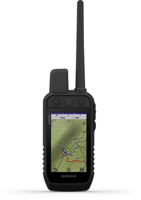
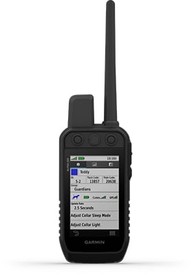
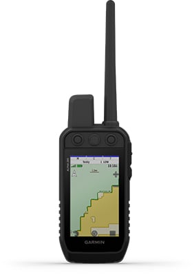
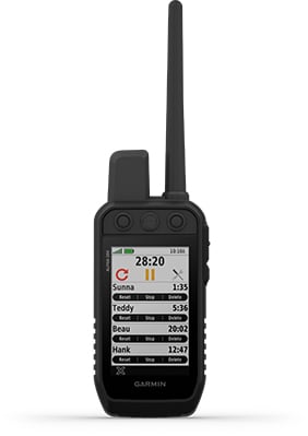
Track your pack from your truck. Monitor and recall your dogs in the field with the Alpha XL dog tracking GPS navigator. It shows you the way, on- or off-road, and pairs directly with your compatible dog collars via VHF radio — so you can follow up to 20 dogs from up to 4 kms away. See the location of your dogs in real time on the large 10" touchscreen display. To reach your hunting grounds, get turn-by-turn navigation for streets, unpaved roads and trails. Once in the field, off-road tools include satellite imagery, high-definition elevation maps, adventure roads and trails content, a 3-axis compass and more. Deliver training commands — from 18 levels of stim, tone and vibe — to your paired training-enabled dog collars from the touchscreen while viewing each dog’s distance traveled, average speed, barks per minute, geofencing alerts, collar battery level and other settings.
Big, Easy To Read Display
An extra-large 10" capacitive touchscreen provides a crisp high-resolution
display for easy readability while driving.
Command Central
The unit’s large touchscreen lets you deliver training commands — from 18
levels of stim, tone and vibration — to your paired collars, enabling quick
adjustments for individual dogs.
Channel View Feature
Monitor the concentration of collars in the area, and easily select less
congested channels to avoid interference.
Track Your Pack
Monitor up to 20 dogs with your compatible dog collars — from up to 4 kms
away — on the color touchscreen map display. Unit is backward compatible
with select Garmin collar devices, so you can track with existing equipment.
Hunt Metrics
See each dog’s daily hunting patterns, distance, speed and time afield, so
you can monitor performance
Satellite Imagery
Download satellite imagery to your device via Wi-Fi® technology, and see
the terrain features from above to help you navigate or find suitable habitat
for your quarry.
KEY FEATURES CONTINUED
WIRELESS CONNECTION NEW
Track and train on or off the in-vehicle dock — connecting wirelessly within 10’ for up to 2 hours.
DIRECT PAIRING NEW
Pairs directly to your compatible Garmin dog collars, so you can easily track and train straight from the Alpha XL navigator.
DOG LIST/GROUP MANAGEMENT
Store up to 250 dogs in your list, and manage active groups.
PRO VIEW COMPASS
Display shows which direction and how far away dogs are — and when a dog is “treed” or “on point.”
COLLAR MONITORING
See battery level, communication state and more for paired collars.
LOCATION AND GEOFENCING ALERTS
Know where your dogs are, and get an alert if they move outside a designated area
ALPHA® APP
Pair with the Alpha smartphone app to see and save real-time dog tracking data.
GARMIN ECOSYSTEM
Alpha XL dog tracking navigator can be integrated easily into your existing Garmin ecosystems, whether with the compatible Alpha dog collars or Alpha handhelds.
MULTI-GNSS SUPPORT
Access multiple satellite systems to track your pack in more challenging environments than GPS alone.
ABC SENSORS
Outdoor sensors include an altimeter, a barometer and a 3-axis electronic compass for rugged-terrain guidance.
MAPS FOR ON- AND OFF ROAD
Get topo and street maps of Australia and New Zealand.
TOPOACTIVE MAPS
See terrain contours, elevations, summits, parks, coastlines, rivers, lakes and more.
OUTDOOR MAPS+
Subscribe to Outdoor Maps+ to view public land information, enhanced topo maps, landowner names and more
RUGGED MOUNTING SYSTEM WITH POWERFUL VHF RADIO ANTENNA
Alpha XL features a powered magnetic VHF dock mounting system with a rugged suction cup mount and remote antenna that magnetically mounts to your vehicle, so you can track your dogs while driving with confidence.
SPECIFICATIONS FOR THE GARMIN ALPHA XL
Unit dimensions (WxHxD) 9.65" x 6.06" x 0.83" (24.5 x 15.4 x 2.1 cm)
Weight Total: 806 g (28.5 oz)
Head Unit: 554 g (19.5 oz)
Radio Mount: 252 g (9 oz)
Display type 10.1" wide view IPS, color TFT, on-lens capacitive touch panel
Display size 8.5" x 5.3" (21.6 x 13.5 cm); 10.1" (25.7 cm) diagonal
Display resolution (WxH) 1280 x 800 pixels
Battery type Rechargeable internal lithium-ion
Battery life Up to 2 hours
Internal storage 64 GB
External storage microSD card (not included)
Includes Alpha XL dog tracking GPS navigator, rugged suction cup with powered VHF mount, socket arm and 1" ball mount, 16" (40.6 cm) magnetic mount, vehicle power cable, charging/data cable, documentation
 New
New
Garmin Montana 760I Rugged GPS Touchscreen Handheld with Inreach Technology and 8-Megapixel Camera
Garmin Montana 760I Rugged GPS Touchscreen Handheld with Inreach Technology and 8-Megapixel Camera
Stay on track and in touch while capturing your adventures.
Get advanced outdoor features, inReach satellite technology for two-way messaging and interactive SOS alerts1 plus a built-in camera — all housed in a rugged 5-inch format that’s ideal for navigation on foot, bike, kayak, ATV and more.
Global Connectivity
With an active inReach subscription, you can stay connected even when your adventures go off grid. Instead of relying on smartphone coverage, now your messages, SOS and tracking are transferred via the 100% global Iridium® satellite network1.
Built-In Camera
Capture images of your adventures with this Montana 760i device, featuring an integrated 8-megapixel autofocus camera. It geotags photos with coordinates, so you can navigate back to favourite sites in the future.
Rugged By Design
This durable, water-resistant handheld is tested to meet MIL-STD 810 for thermal, shock, water and vibration. It features a glove-friendly 5-inch touchscreen and is compatible with a variety of robust mounting solutions (sold separately) to best suit your activities.
Topoactive Maps
To navigate your adventures, use preloaded topographical maps. View terrain contours, elevations, coastlines, rivers, landmarks and more.
Satellite Views
Access subscription-free, high-resolution satellite imagery with direct-to-device downloads over Wi-Fi® connectivity. See photorealistic overhead views of routes and surrounding terrain, and easily create waypoints based on landmarks.
Outdoor Maps+
Add a subscription to Outdoor Maps+ (sold separately), and get ongoing access to a wide variety of premium mapping content and regular updates sent right to your Garmin device via Wi-Fi technology.
More Features for Garmin Montana 760I Rugged GPS Touchscreen Handheld with Inreach Technology and 8-Megapixel Camera:
Inreach Features
- Two-Way Messaging: Exchange text messages with loved ones back home, or communicate via inReach device to inReach device in the field.
- Interactive SOS: In case of emergency, trigger an interactive SOS message to Garmin Response?, a 24/7-staffed professional emergency response coordination centre.
- Inreach Weather: Available inReach weather forecast service provides detailed updates directly to your Montana handheld or paired devices, so you’ll know what to expect en route.
- Live Tracking: Using your live tracking page, followers can see your progress, ping your device to see your GPS location and exchange messages during your trip.
Navigation Features
- Garmin Explore App: Pair with the Garmin Explore App to plan and review trip data, plus manage your waypoints, courses and activities.
- Multi-GNSS Support: Access to GPS and Galileo satellite networks enables Montana 760i to track in more challenging environments than GPS alone.
- ABC Sensors: Navigate your next trail with ABC sensors, including an altimeter for elevation data, barometer to monitor weather and 3-axis electronic compass.
- City Navigator Maps: Seamlessly transition from trails to road navigation with preloaded New Zealand Navigator street mapping, which guides your drive with easy-to-follow turn-by-turn directions.
- Additional Maps: With 32 GB of onboard memory, you can download even more maps, such as BlueChart® g3 charts for the water (sold separately).
- Active Weather: Access up-to-date active weather forecasts via the Garmin Connect™ app on your compatible smartphone
- Dog Tracking: For hunters and trainers, this Montana handheld syncs with your compatible Astro® or Alpha® series handhelds to help track sporting dogs in the field.
- Wikiloc Trails: This preloaded app lets you easily download hiking, cycling and other Wikiloc trails shared by outdoor enthusiasts like you. Get a free 60-day Wikiloc Premium trial to try this and other exclusive features. Learn more.
Adventure Features
- Expedition Mode: Trek far and wide off-grid. Use expedition mode, an ultralow-powered GPS reference, to keep Montana tracking for more than 2 weeks between recharges.
- Battery Options: An internal lithium-ion battery pack provides up to 24 hours of battery life in GPS mode and recharges with a standard USB-C® cable.
- Vehicle Mounts: A variety of Montana handheld-compatible mounts (sold separately) lets you adapt your navigator for use on ATVs, boats, cars, motorcycles, motorhomes or other vehicles.
Specifications for Garmin Montana 760I Rugged GPS Touchscreen Handheld with Inreach Technology and 8-Megapixel Camera:
General
- Lens Material: Chemically strengthened glass
- Dimension: 9.19 x 18.30 x 3.27 cm (3.6? x 7.2? x 1.3?)
- Weight: 410g (14.5oz) with included lithium-ion battery pack
- Water Rating: IPX7
- MIL-STD-810: Yes (thermal, shock, water, vibe)
- Touchscreen
- Display Type: WVGA transflective, dual orientation
- Display Size: 6.48 x 10.80 cm (2.55?W x 4.25?H); 12.70 cm (5? diag)
- Display Resolution: 480 x 800 pixels
- Batter Type: Rechargeable lithium-ion (included)
- Battery Life:
- GPS Mode: up to 24 hours (including when a text message or location is sent every 10 minutes)
- Expedition Mode: up to 440 hours or up to 300 hours with a text message or location sent every 30 minutes
- Powered Off: up to 1 year
- Note – Battery life estimates are with full sky view and can be significantly impacted by obstructions or tree cover.
- Memory/History: 32 GB (user space varies based on included mapping)
- Interface: USB-C
Maps & Memory
- Preloaded maps: Yes (TopoActive Australia, New Zealand & Africa; City Navigator Australia, New Zealand & Africa - Additional regions can be downloaded over Wi-Fi®)
- Ability to add maps
- Basemap
- Automatic routing (turn by turn routing on roads) for outdoor activities
- Automatic routing (turn by turn routing on roads) for motorized vehicles
- Map segments: 15 000
- Satellite Imagery: Yes (direct to device)
- Includes detailed hydrographic features (coastlines, lake/river shorelines, wetlands and perennial and seasonal streams)
- Includes searchable points of interests (parks, campgrounds, scenic lookouts and picnic sites)
- Displays national, state and local parks, forests, and wilderness areas
- External memory storage: Yes (32 GB max microSD™ card)
- Waypoints/favorites/locations: 10 000
- Courses: 250, 200 course points per course
- Tracks: 250
- Navigation Track Log: 20,000 points, 250 saved gpx tracks, 300 saved fit activities
- Navigation Routes: 250, 250 points per route; 50 points auto routing
- Rinex logging
Sensors
- GPS
- Galileo
- Barometric altimeter
- Compass: Yes (tilt-compensated 3-axis)
- High-sensitivity receiver
- GPS compass (while moving)
Daily Smart Features
- Connect IQ™ (downloadable watch faces, data fields, widgets and apps)
- Smart notifications on handheld
- Weather forecasts
- Active Weather
- Compatible with Garmin Messenger app
- VIRB® Remote
- Pairs with Garmin Connect™ Mobile
Safety and Tracking Features
- LiveTrack
Tactical Features
- Ballistics solver
- XERO™ Locations
Outdoor Recreation
- Point-to-point navigation
- TracBack®
- Area calculation
- FISH FORECAST
- Sun and moon information
- Geocaching-friendly: Yes (Geocache Live)
- Custom maps compatible: Yes (500 custom map tiles)
- Picture viewer
- Camera: Yes (8 megapixel with autofocus; automatic geo-tagging)
- LED beacon flashlight
Inreach Features
- Interactive SOS
- inReach weather
- Send and receive text messages to SMS and email
- Send and receive text messages to other inReach device
- Send and receive group messages
- Exchange locations with other inReach device
- MapShare compatible with tracking
- Virtual keyboard for custom messaging
- Send waypoints to MapShare during trip
- Send route selection to MapShare during trip
Outdoor Applications
- Compatible with Garmin Explore™ app
- Garmin Explore website compatible
- Smart switching between Wi-Fi, Mobile and Satellite with Garmin Messenger app
- Dog tracking
*Active satellite subscription required. Some jurisdictions regulate or prohibit the use of satellite communication devices. It is the responsibility of the user to know and follow all applicable laws in the jurisdictions where the device is intended to be used.
Wi-Fi is a registered trademark of the Wi-Fi Alliance. USB-C is a registered trademark of USB Implementers Forum.
Engineering enhancements are ongoing and may not be reflected in the pictures, videos and specifications.

 New
New
Garmin Montana 710I Rugged GPS Touchscreen Handheld with Inreach Technology
Garmin Montana 710I Rugged GPS Touchscreen Handheld with Inreach Technology
Stay on track and in touch through all kinds of adventures.
Get advanced outdoor features — plus inReach technology for two-way messaging and interactive SOS alerts1 — in a rugged 5-inch format that’s ideal for navigation on foot, bike, kayak, ATV and more.
Global Connectivity
With an active inReach subscription, you can stay connected even when your adventures go off grid. Instead of relying on smartphone coverage, now your messages, SOS and tracking are transferred via the 100% global Iridium® satellite network
Rugged By Design
This durable, water-resistant handheld is tested to meet MIL-STD 810 for thermal, shock, water and vibration. It features a glove-friendly 5-inch touchscreen and is compatible with a variety of robust mounting solutions (sold separately) to best suit your activities.
Topoactive Maps
To navigate your adventures, use preloaded topographical maps. View terrain contours, elevations, coastlines, rivers, landmarks and more.
Satellite Views
Access subscription-free, high-resolution satellite imagery with direct-to-device downloads over Wi-Fi® connectivity. See photorealistic overhead views of routes and surrounding terrain, and easily create waypoints based on landmarks.
Outdoor Maps+
Add a subscription to Outdoor Maps+ (sold separately), and get ongoing access to a wide variety of premium mapping content and regular updates sent right to your Garmin device via Wi-Fi technology.
Garmin Explore App
Pair with the Garmin Explore App to plan and review trip data, plus manage your waypoints, courses and activities.
More Features for Garmin Montana 710I Rugged GPS Touchscreen Handheld with Inreach Technology:
Navigation Features
- Multi-GNSS Support: Access to GPS and Galileo satellite networks enables Montana 710i to track in more challenging environments than GPS alone.
- ABC Sensors: Navigate your next trail with ABC sensors, including an altimeter for elevation data, barometer to monitor weather and 3-axis electronic compass.
- City Navigator Maps: Seamlessly transition from trails to road navigation with preloaded New Zealand Navigator street mapping, which guides your drive with easy-to-follow turn-by-turn directions.
- Additional Maps: With 32 GB of onboard memory, you can download even more maps, such as BlueChart® g3 charts for the water (sold separately).
- Active Weather: Access up-to-date active weather forecasts via the Garmin Connect™ app on your compatible smartphone
- Dog Tracking: For hunters and trainers, this Montana handheld syncs with your compatible Astro® or Alpha® series handhelds to help track sporting dogs in the field.
- Wikiloc Trails: This preloaded app lets you easily download hiking, cycling and other Wikiloc trails shared by outdoor enthusiasts like you. Get a free 60-day Wikiloc Premium trial to try this and other exclusive features.
Inreach Features
- Two-Way Messaging: Exchange text messages with loved ones back home, or communicate via inReach device to inReach device in the field1.
- Interactive SOS: In case of emergency, trigger an interactive SOS message to Garmin Response?, a 24/7-staffed professional emergency response coordination centre1.
- Inreach Weather: Available inReach weather forecast service provides detailed updates directly to your Montana handheld or paired devices, so you’ll know what to expect en route1.
- Live Tracking: Using your live tracking page, followers can see your progress, ping your device to see your GPS location and exchange messages during your trip1.
Adventure Features
- Expedition Mode: Trek far and wide off-grid. Use expedition mode, an ultralow-powered GPS reference, to keep Montana tracking for more than 2 weeks between recharges.
- Battery Options: An internal lithium-ion battery pack provides up to 24 hours of battery life in GPS mode and recharges with a standard USB-C® cable.
- Vehicle Mounts: A variety of Montana handheld-compatible mounts (sold separately) lets you adapt your navigator for use on ATVs, boats, cars, motorcycles, motorhomes or other vehicles.
Specifications for Garmin Montana 710I Rugged GPS Touchscreen Handheld with Inreach Technology:
General
- Lens Material: Chemically strengthened glass
- Dimension: 9.19 x 18.30 x 3.27 cm (3.6? x 7.2? x 1.3?)
- Weight: 410g (14.5oz) with included lithium-ion battery pack
- Water Rating: IPX7
- MIL-STD-810: Yes (thermal, shock, water, vibe)
- Touchscreen
- Display Type: WVGA transflective, dual orientation
- Display Size: 6.48 x 10.80 cm (2.55?W x 4.25?H); 12.70 cm (5? diag)
- Display Resolution: 480 x 800 pixels
- Battery Type: Rechargeable lithium-ion (included)
- Battery Life:
- GPS Mode: up to 24 hours (including when a text message or location is sent every 10 minutes)
- Expedition Mode: up to 440 hours or up to 300 hours with a text message or location sent every 30 minutes
- Powered Off: up to 1 year
- Note – Battery life estimates are with full sky view and can be significantly impacted by obstructions or tree cover.
- Memory/History: 32 GB (user space varies based on included mapping)
- Interface: USB-C
Maps & Memory
- Preloaded Maps: Yes (TopoActive Australia, New Zealand & Africa; City Navigator Australia, New Zealand & Africa - Additional regions can be downloaded over Wi-Fi®)
- Ability to Add Maps:
- Basemap:
- Automatic Routing (Turn by Turn Routing on Roads) For Outdoor Activities
- Automatic Routing (Turn by Turn Routing on Roads) For Motorized Vehicles
- Map Segments: 15 000
- Satellite Imagery: Yes (Direct to Device)
- Includes detailed hydrographic features (coastlines, lake/river shorelines, wetlands and perennial and seasonal streams)
- Includes searchable points of interests (parks, campgrounds, scenic lookouts and picnic sites)
- Displays national, state and local parks, forests, and wilderness areas
- External memory storage: Yes (32 GB max microSD card)
- Waypoints/favorites/locations
- Courses: 250, 200 course points per course
- Tracks: 250
- Navigation Track Log: 20,000 points, 250 saved gpx tracks, 300 saved fit activities
- Navigation Routes: 250, 250 points per route; 50 points auto routing
- Rinex logging
Sensor
- GPS
- Galileo
- Barometric altimeter
- Compass: Yes (tilt-compensated 3-axis)
- High-sensitivity receiver
- GPS compass (while moving)
Daily Smart Features
- Connect IQ™ (downloadable watch faces, data fields, widgets and apps)
- Smart notifications on handheld
- Weather forecasts
- Active Weather
- Compatible with Garmin Messenger app
- VIRB® Remote
- Pairs with Garmin Connect™ Mobile
Outdoor Recreation
- Point-to-point navigation
- TracBack®
- Area calculation
- FISH FORECAST
- Sun and moon information
- Geocaching-friendly: Yes (Geocache Live)
- Custom maps compatible: Yes (500 custom map tiles)
- Picture viewer
- LED beacon flashlight
Inreach Features
- Interactive SOS
- inReach weather
- Send and receive text messages to SMS and email
- Send and receive text messages to other inReach device
- Send and receive group messages
- Exchange locations with other inReach device
- MapShare compatible with tracking
- Virtual keyboard for custom messaging
- Send waypoints to MapShare during trip
- Send route selection to MapShare during trip
Tactical Features
- XERO™ Locations
- Ballistics solver
Outdoor Applications
- Compatible with Garmin Explore™ app
- Garmin Explore website compatible
- Smart switching between Wi-Fi, Mobile and Satellite with Garmin Messenger app
- Dog tracking: Yes (when paired to compatible dog track system)
Safety and Tracking Features
- LiveTrack
*Active satellite subscription required. Some jurisdictions regulate or prohibit the use of satellite communication devices. It is the responsibility of the user to know and follow all applicable laws in the jurisdictions where the device is intended to be used.
Wi-Fi is a registered trademark of the Wi-Fi Alliance. USB-C is a registered trademark of USB Implementers Forum.
Engineering enhancements are ongoing and may not be reflected in the pictures, videos and specifications.
 New
New
Garmin Overlander GPS AUS/NZ
ROAM THE UNKNOWN
Built for every part of the journey, Overlander is the rugged, all-terrain navigator with on- and off-road navigation.
Get the lay of the land with topographic maps for Australia and New Zealand.
Or get spoken directions to the nearest coffee shop with street maps.
Share1 the plans for adventure through Garmin Explore. From your laptop to your phone to your friends.
Comes with a powered magnetic mount and a RAM ball mount. It’s not going anywhere.
Search for the nearest inspiration point while you’re in the middle of nowhere.
Need to bring your own satellite imagery? How does 64 GB of built-in storage sound?
ON AND OFF ROAD
7” colour touchscreen features turn-by-turn directions for on-road and off-road navigation covering Australia and New Zealand. Includes 64 GB internal memory to download additional TOPO maps
MILITARY STANDARD 810
Overlander is built to the U.S. military standard 810 for thermal and shock resistance. It can be mounted anywhere, thanks to the powered magnetic mount that comes with suction cup and 1” RAM ball compatible adapter.
IP5X DUST RATING
This essential piece of overlanding gear is purpose-built from the circuit board up and is designed to withstand dust and extreme temperatures.
GARMIN EXPLORE
Use the Garmin Explore app to download additional maps – such as satellite imagery and USGS quad sheets on 64 GB of internal storage – and sync all your data between devices. Easily import and export GPX files to Garmin Explore — even if offline.
FIND CAMPSITES
Overlander is preloaded with iOverlander POIs and Ultimate Public Campgrounds, so you don’t need a cell signal to route to the best-established, wild and dispersed campsites.
FIND BOUNDARIES
Overlander features preloaded topography for Australia and New Zealand. Download additional topographic maps worldwide on the 64 GB of internal storage.
KNOW YOUR VEHICLE
Customize street navigation for the size and weight of your overlanding vehicle, plus get alerts for upcoming bridge heights, weight limits, sharp curves, steep grades and more.
MULTI-GNSS SUPPORT
GPS, GLONASS and Galileo support helps track in more challenging environments than GPS alone.
NAVIGATION TOOLS
All of your overlanding equipment – such as a built-in compass, altimeter and barometer – is now in one device.TRACK RECORDER
Record your tracks, and save them to your Garmin Explore account so you can review them later on any device or share them with friends.
PITCH AND ROLL
Overlander comes with integrated pitch and roll angles to help you and your vehicle navigate difficult terrain.
INREACH® COMPATIBLE
Pair your Overlander navigator with the inReach Explorer®+, inReach SE®+ and inReach® Mini satellite communicators2 (sold separately) for two-way text messaging, interactive SOS and weather forecasts.
BACKUP CAMERA COMPATIBLE
Pair your Overlander with up to 4 of our BC™ 35 wireless backup cameras (sold separately) so you can see what’s behind you.
PHYSICAL DIMENSIONS W x H x D 19.9 x 12.2 x 2.4 cm
DISPLAY SIZE W x H 15.2 x 8.9 cm; 7" diagonal
DISPLAY RESOLUTION 1024 x 600 pixels
DISPLAY TYPE Multi-touch, glass, WSVGA colour TFT with white backlight
WEIGHT 437 g
BATTERY TYPE Rechargeable lithium-ion
BATTERY LIFE Up to 3 hours
DROP RATING MIL-STD-810
DUST RATING IP5X
 New
Sale
New
Sale
Garmin Bundle Alpha 200 GPS/T20 Dog Collar
Garmin Bundle Alpha 200 GPS/T20 Dog Collar Combo Package
STRONG CONNECTION. STRONG BOND. Track and train your dogs with the Alpha 200, Handheld Only system, a sunlight-readable 3.50" capacitive touchscreen and user-friendly, six-button design.
Key Features:
• This handheld is designed to help make tracking and training simple, accessible and fast.
• Track and train your pack while they’re out in the field.
• Keep inactive dogs in the system for easier setup and management.
• Navigate every hunt with the best in Garmin mapping and sensors.
• User-replaceable battery lasts up to 20 hours.
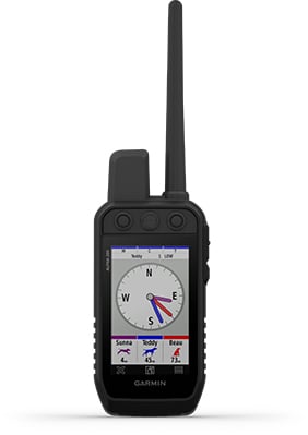
TRACK YOUR PACK. Monitor up to 20 dogs from up to 14.50 kilometres (depending on dog device) with a 2.50-second update rate.
DOG LIST/GROUP MANAGEMENT. Keep inactive dogs in your dog list, and manage active groups so you don’t have to add and remove dogs for every hunt.
PUBLIC LAND BOUNDARIES. Optional display of public land boundaries on topographical maps helps you know that you’re venturing where you’re supposed to be.
HUNT METRICS. See each dog’s daily hunting patterns, distance and speed so you can monitor performance and help prevent overheating. Pair with TT™ 15 tracking and training collars.

SIX-BUTTON DESIGN. Use dedicated buttons for fast training cues and minor adjustments in the field.
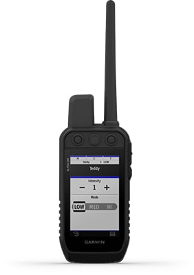
18 LEVELS OF STIMULATION. Momentary and continuous stimulation options let you customise training for each dog.
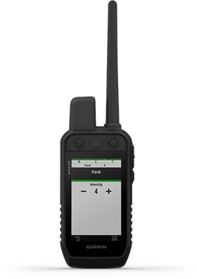
TONE/VIBRATION. Issue different levels of audible tone or vibration commands for quick adjustments to individual dogs.
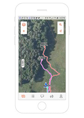
GARMIN EXPLORE™ APP. Pair with the Garmin Explore app on your compatible smartphone to see real-time dog tracking information, save collections of dog tracks and replay tracks to see exactly what happened during your hunt.
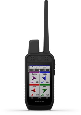
PRO VIEW COMPASS. The pro view compass mode gives you simple, at-a-glance tracking that shows which direction and how far away your dogs are, plus you will see when a dog is “Treed” or “OnPoint.”
MULTI-GNSS SUPPORT. Access multiple global navigation satellite systems (GPS and Galileo) to track your pack with greater accuracy than GPS alone.
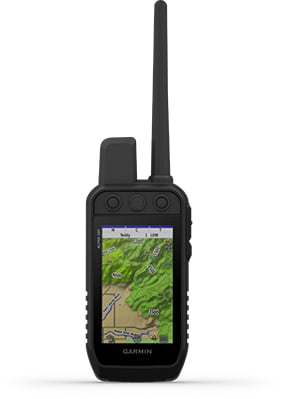
TOPOACTIVE MAPS. Our preloaded TopoActive mapping provides detailed views of terrain contours, topographic elevations, summits, parks, coastlines, rivers, lakes and geographical points.
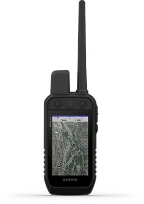
BIRDSEYE DIRECT. Download BirdsEye Satellite Imagery directly to the handheld for better-than-real-life views of your route, trailheads, clearings and more.
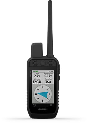
NAVIGATION SENSORS. A barometric altimeter helps you accurately monitor ascent and descent and see short-term trends in air pressure, and the built-in tilt-compensated 3-axis electronic compass keeps your bearing - whether you’re moving or not.
SEE IT ALL. The sunlight-readable 3.50? capacitive touchscreen display makes it easy to see and interact with your maps, dog data and more — even while wearing gloves.
STAY ON THE MOVE. Replaceable battery lasts up to 20 hours, giving you plenty of hunt time with your dogs in the field.
ADDITIONAL MAPPING. The microSD™ card slot allows you to load more mapping options, such as TOPO Australia and New Zealand Light and HuntView maps (each sold separately).
Specifications:
General
• PHYSICAL DIMENSIONS: 7.70 x 6.40 x 1.30? (6.80 x 16.20 x 3.40 cm) *dimensions do not include antenna
• TOUCHSCREEN: Yes
• DISPLAY SIZE: 1.80? W x 3.0? H (4.70 x 7.70 cm); 3.50? diag (88.90 mm)
• DISPLAY RESOLUTION: 282 x 470 pixels
• DISPLAY TYPE: Transflective, colour TFT touchscreen
• WEIGHT: 9.90 oz (280 g) with standard antenna and battery
• BATTERY TYPE: Rechargeable lithium-ion (included)
• BATTERY LIFE: Up to 20 hours
• WATER RATING: IPX7
• HIGH-SENSITIVITY RECEIVER: Yes
• INTERFACE: High-speed USB
• MEMORY/HISTORY: 16 GB
• PRODUCT NUMBER: 010-02616-53
Maps & Memory
• PRELOADED MAPS: Yes (TopoActive)
• ABILITY TO ADD MAPS: Yes
• BASEMAP: Yes
• AUTOMATIC ROUTING (TURN BY TURN ROUTING ON ROADS) FOR OUTDOOR ACTIVITIES: Yes (with optional mapping for detailed roads)
• BIRDSEYE: Yes, direct to device (no annual subscription required)
• EXTERNAL MEMORY STORAGE: microSD™ card (not included)
• WAYPOINTS/FAVORITES/LOCATIONS: 10,000
• TRACKS: Up to 20 dogs (TT 15/TT 15 mini and T5/T5 mini) and buddies (Alpha 100 and Alpha 200) simultaneously
• TRACK LOG: 20,000 points, 200 saved gpx tracks, 300 saved fit activities
• ROUTES: 250
• STORED CONTACTS: 250 dogs
• GROUP MANAGEMENT: Yes
Sensors
• BAROMETRIC ALTIMETER: Yes
• COMPASS: Yes (tilt-compensated 3-axis)
Outdoor Recreation
• SUN AND MOON INFORMATION: Yes
• CUSTOM MAPS COMPATIBLE: Yes
Two-way Radio Features
• FREQUENCY BAND: MURS
• RANGE: TT 15/T5, 14.50 kilometres; TT 15 mini/T mini, 14.50 kilometres
Outdoor Applications
• COMPATIBLE WITH GARMIN EXPLORE™ APP: Yes
• GARMIN EXPLORE WEBSITE COMPATIBLE: Yes
Connections
• WIRELESS CONNECTIVITY: Yes (Wi-Fi®, Bluetooth® and ANT+®)
Garmin T20 - TRACK YOUR PACK.
No matter what kind of dogs you run or how you hunt, Garmin Alpha® T 20 is the slim, rugged and universally sized collar designed to help you build a better dog — no matter the breed.
Key Features:
- Track your dog up to 14.5 kilometers when used with a compatible handheld (sold separately)
- Optimise your battery life with dynamic tracking
- Collar is universally sized to fit large and small breeds
- Easily change the user-replaceable flex band
- Uses multicolour location beacon for low-light conditions
- Get automatic software updates when charging and connected to your network with Wi-Fi® technology
TRACKING
The top-mounted, high-sensitivity GPS and Galileo receiver keeps track of your dog’s location, and the Alpha® T 20 collar transmits that location via VHF up to 14.5 kilometers away with updates as frequent as every 2.5 seconds when used with a compatible handheld (sold separately).
UNIVERSAL SIZING
A rugged yet slim design is universally sized to fit large and small breeds.
DYNAMIC TRACKING
Get extended battery life with dynamic tracking based on your dog’s movement.
RUGGED DESIGN
The collar features a user-replaceable flex band that can withstand the toughest outdoor environments.
LED BEACON LIGHTS
This collar features bright, multicolour LED beacon lights to help you identify and track your dog in low-light conditions. They can be remotely activated and changed from a compatible handheld (sold separately).
REPLACEABLE BATTERY PACKS
When using dynamic tracking, get up to 68 hours with the standard battery pack and up to 136 with the extended battery pack (sold separately).
AUTOMATIC UPDATES
Receive automatic software updates when Alpha® T 20 is charging and connected to your network with Wi-Fi technology.
PAIR WITH HANDHELDS
The Alpha® T 20 GPS dog collar easily pairs with Garmin dog tracking handhelds, such as the Alpha® series (sold separately).
Specifications:
- Unit dimensions (WxHxD): 8.1 x 4.5 x 3.5 cm (3.2? x 1.8? x 1.4?)
- Weight: 168.5 g (5.9 oz) for transmitter and antenna (without collar), 239.5 g (8.4 oz) total weight (with collar)
- Battery type: Rechargeable lithium-ion pack; user-replaceable
- Battery life: Standard battery pack (included) - up to 68 hours using dynamic tracking (default), up to 25 hours with location updates every 2.5 seconds, up to 84 hours with location updates every 2 minutes, Extended battery pack (sold separately), up to 136 hours using dynamic tracking (default), up to 50 hours with location updates every 2.5 seconds, up to 168 hours with location updates every 2 minutes
- Range: 14.5
- Interface: USB-C
- Water rating: 1 ATM (10 metres)
- Neck size: With standard 1? collar strap: minimum of 9.5? (24 cm) in circumference, With flipped 1? collar strap: minimum of 6.5? (16.5 cm) in circumference
- High-sensitivity GPS/Galileo receiver: Yes
- GPS antenna: Top-mounted, orange
- Vibration/Tone: Not available in the U.S.; may be available in other regions
- LED beacon lights: Yes (multiple colour options)
- Flex band: User-replaceable
- Sleep mode: Yes (Alpha® Series only)
- Rescue mode: Yes
- Frequency mode: VHF
- Replaceable collar straps: Yes
- Collar compatibility: Up to 1? (2.54 cm)
- Automatic software updates: Wi-Fi® technology (when charging and connected to a network)
- Manufacturer code: 010-02447-03
 New
New
Garmin Montana 710 Rugged GPS Touchscreen Handheld
Garmin Montana 710 Rugged GPS Touchscreen Handheld
Stay on track through all kinds of adventures.
With routable mapping for roads and trails, the Montana 710 handheld brings advanced outdoor features into a sturdy 5-inch format that’s ideal for navigation on foot, bike, kayak, ATV and more.
Rugged by Design
This durable, water-resistant handheld is tested to meet MIL-STD 810 for thermal, shock, water and vibration. It features a glove-friendly 5-inch touchscreen and is compatible with a variety of robust mounting solutions (sold separately) to best suit your activities.
Topoactive Maps
To navigate your adventures, use preloaded topographical maps. View terrain contours, elevations, coastlines, rivers, landmarks and more.
Satellite Views
Access subscription-free, high-resolution satellite imagery with direct-to-device downloads over Wi-Fi® connectivity. See photorealistic overhead views of routes and surrounding terrain, and easily create waypoints based on landmarks
Additional Maps
With 32 GB of onboard memory, you can download even more maps, such as City Navigator® maps for your drive or BlueChart® g3 charts for the water (sold separately).
Outdoor Maps+
Add a subscription to Outdoor Maps+ (sold separately), and get ongoing access to a wide variety of premium mapping content and regular updates sent right to your Garmin device via Wi-Fi technology.
Garmin Explore App
Pair with the Garmin Explore App to plan and review trip data, plus manage your waypoints, courses and activities.
More Features of Garmin Montana 710 Rugged GPS Touchscreen Handheld:
Navigation Features
- Multi-GNSS Support: Access to GPS and Galileo satellite networks enables Montana 710 to track in more challenging environments than GPS alone.
- ABC Sensors: Navigate your next trail with ABC sensors, including an altimeter for elevation data, barometer to monitor weather and 3-axis electronic compass.
- Active Weather: Access up-to-date active weather forecasts via the Garmin Connect™ app on your compatible smartphone
- Dog Tracking: For hunters and trainers, this Montana handheld syncs with your compatible Astro® or Alpha® series handhelds to help track sporting dogs in the field.
- Wikiloc Trails: This preloaded app lets you easily download hiking, cycling and other Wikiloc trails shared by outdoor enthusiasts like you. Get a free 60-day Wikiloc Premium trial to try this and other exclusive features. Learn more.
Adventure Features
- Expedition Mode: Trek far and wide off-grid. Use expedition mode, an ultralow-powered GPS reference, to keep Montana tracking for more than 2 weeks between recharges.
- Battery Options: An internal lithium-ion battery pack provides up to 24 hours of battery life in GPS mode and recharges with a standard USB-C® cable.
- Vehicle Mounts: A variety of Montana handheld-compatible mounts (sold separately) lets you adapt your navigator for use on ATVs, boats, cars, motorcycles, motorhomes or other vehicles.
Specifications for Garmin Montana 710 Rugged GPS Touchscreen Handheld:
General
- Lens Material: Chemically strengthened glass
- Dimension: 8.76 x 18.30 x 3.27 cm (3.5? x 7.2? x 1.3?)
- Weight: 410g (14.5oz) with included lithium-ion battery pack
- Water rating: IPX7
- MIL-STD-810: Yes (thermal, shock, water, vibe)
- Touchscreen
- Display Type: WVGA transflective, dual orientation
- Display Size: 6.48 x 10.80 cm (2.55?W x 4.25?H); 12.70 cm (5? diag)
- Display Resolution: 480 x 800 pixels
- Battery type: Rechargeable lithium-ion (included)
- Battery life:
- GPS Mode: up to 24 hours
- Expedition Mode: up to 440 hours
- Powered Off: up to 1 year
- Note – Battery life estimates are with full sky view and can be significantly impacted by obstructions or tree cover.
- Memory/History: 32 GB (user space varies based on included mapping)
- Interface: USB-C
Maps & Memory
- Preloaded maps: Yes (TopoActive Australia - Additional regions can be downloaded over Wi-Fi®)
- Ability to add maps
- Basemap
- Automatic routing (turn by turn routing on roads) for outdoor activities
- Map segments: 15 000
- Satellite Imagery: Yes (direct to device)
- Includes detailed hydrographic features (coastlines, lake/river shorelines, wetlands and perennial and seasonal streams)
- Includes searchable points of interests (parks, campgrounds, scenic lookouts and picnic sites)
- Displays national, state and local parks, forests, and wilderness areas
- External memory storage: Yes (32 GB max microSD™ card)
- Waypoints/favorites/locations: 10 000
- Courses: 250, 200 course points per course
- Tracks: 250
- Navigation Track Log: 20,000 points, 250 saved gpx tracks, 300 saved fit activities
- Navigation Routes: 250, 250 points per route; 50 points auto routing
- Rinex logging
Sensors
- GPS
- GLONASS
- Galileo
- Barometric altimeter
- Compass: Yes (tilt-compensated 3-axis)
- High-sensitivity receiver
- GPS compass (while moving)
Daily Smart Features
- Connect IQ™ (downloadable watch faces, data fields, widgets and apps)
- Smart notifications on handheld
- Weather forecasts
- Active Weather
- Compatible with Garmin Messenger app
- VIRB® Remote
- Pairs with Garmin Connect™ Mobile
Safety and Tracking Features
- LiveTrack
Tactical Features
- XERO™ Locations
Outdoor Recreation
- Point-to-point navigation
- TracBack®
- Area calculation
- FISH FORECAST
- Sun and moon information
- Geocaching-friendly: Yes (Geocache Live)
- Custom maps compatible: Yes (500 custom map tiles)
- Picture viewer
- LED beacon flashlight
InReach Features
- inReach remote compatible
Outdoor Applications
- Compatible with Garmin Explore™ app
- Garmin Explore website compatible
- Dog tracking: Yes (when paired to compatible dog track system)
Connections
- Connections Wireless Connectivity: Yes (Wi-Fi®, BLUETOOTH®, ANT+®)
Wi-Fi is a registered trademark of the Wi-Fi Alliance. USB-C is a registered trademark of USB Implementers Forum.
Engineering enhancements are ongoing and may not be reflected in the pictures, videos and specifications.

 New
New
Garmin Foretrex 901 Ballistic Edition Wrist-Mounted GPS Navigator with Strap
Garmin Foretrex 901 Ballistic Edition Wrist-Mounted GPS Navigator with Strap
This GPS navigator features an easy-to-read monochromatic display, multi-band GNSS and advanced navigation sensors to help you explore with confidence. When it’s time to calculate a long-range shot, use the Applied Ballistics® software on the device.
Ballistic Solver
Calculate the perfect shot with the included Applied Ballistics software. Use your compatible smartphone to wirelessly connect to the AB Synapse™ – Garmin app to manage ballistic profiles.
Durable
Tested to military standards (MIL-STD-810) to withstand sand and dust, vibration, shock, temperature, altitude, humidity and more. The rugged design features an IPX7 water-resistant rating.
Long Battery Life
Get up to 100 hours of battery life in navigation mode or up to 1000 hours in expedition mode; uses 2 field-replaceable AAA batteries (not included).
Tactical Features
Use stealth mode to stop storing and sharing GPS data and disable wireless connectivity. In case of security issues, hit the kill switch to erase the device memory. Use jumpmaster mode to calculate high-altitude release points in accordance with military guidelines.
Navigation Sensors
Navigate the terrain with advanced sensors, including a 3-axis accelerometer, 3-axis compass and barometric altimeter. Get improved position accuracy with upgraded multi-band GNSS.
Connect Your Devices
Get smart notifications when linked with your compatible smartphone. Pair with your compatible inReach® satellite communicator, and view messages directly on the screen.
Specifications for Garmin Foretrex 901 Ballistic Edition Wrist-Mounted GPS Navigator with Strap:
General
- Lens Material: acrylic
- QuickFit® watch band compatible: Yes (26 mm)
- Dimension: 7.4 x 4.3 x 2.3 cm (2.9? x 1.7? x 0.9?)
- Weight: 108 g (3.8 oz) with batteries
- Water Rating: IPX7
- MIL-STD-810: Yes (thermal, shock, water); bare unit only
- Display Type: Monochrome MIP
- Display Size: 2.2? diagonal
- Display Resolution: 320 x 240 pixels
- Battery type: 2 AAA batteries (not included)
- Battery life:
- Up to 100 hours in default GPS Mode
- Up to 1,000 hours in expedition mode
- Interface: USB-C
Maps & Memory
- Waypoints/favorites/locations: 500
- Courses: 500
- Tracks: 100
- Navigation Track Log: 10,000
- Navigation Routes: 50
Sensors
- GPS
- GLONASS
- Galileo
- Multi-frequency Positioning
- Barometric altimeter
- Compass: Yes (tilt-compensated 3-axis)
- GPS compass (while moving)
Daily Smart Features
- Smart notifications on handheld
- Pairs with Garmin Connect™ Mobile
Tactical Features
- Stealth Mode
- Night vision mode
- Dual grid coordinates
- KILL SWITCH
- Ballistics solver
- Compatible with AB Synapse
Outdoor Recreation
- Point-to-point navigation
- TracBack®
- FISH FORECAST
- Sun and moon information
Outdoor Applications
- Compatible with Garmin Explore™ app
- Garmin Explore website compatible
Connections
- Connections Wireless Connectivity: Yes (Bluetooth®, ANT+®)
Satellite subscription required. Some jurisdictions regulate or prohibit the use of satellite communication devices. It is your responsibility to know and follow all applicable laws in the jurisdictions where the device is intended to be used.
Engineering enhancements are ongoing and may not be reflected in the pictures, videos and specifications.

 New
New
Garmin Xero C1 Pro Chronograph
CAPTURE PRECISION. EXECUTE PERFECTION.
The most essential data for ballistics calculations is projectile speed. A chronograph is the best tool for the job. Whether you’re handloading for the range or building arrows for the hunt, the Xero C1 Pro chronograph provides the speed data you need to hone your craft.
• Measure projectile speeds from 100 fps to 5,000 fps.
• The button-operated design is simple to use.
• Pair with the ShotView™ smartphone app to track your shots, measure deviation and more.
• It’s built to endure the elements with an IPX7 water-resistant rating.
• The compact design fits in your back pocket and is easy to set up.
• Battery life for up to 2,000 shots or up to 6 hours gives you plenty of time at the range.
RELIABLE PERFORMANCE
The chronograph will reliably pick up your shots, thanks to the sensitive and accurate sensor.
VERSATILE PERFORMANCE
The device can measure projectile speeds from 100 fps to 5,000 fps for bullets, arrows, slugs, birdshot, airsoft BBs, pellets and paintballs.
EASY TO OPERATE
Indoor and outdoor operation is simple, thanks to the backlit display and button-operated design.
PURPOSE-BUILT APP
Keep track of your shots, measure deviation and more when paired with the ShotView app on your compatible smartphone.
SIMPLE SETUP
Turn it on. Set it up. Point it in the direction of fire, and shoot.
RECHARGEABLE BATTERY
With battery life for up to 2,000 shots or up to 6 hours, there’s no rush. Take your time at the range while you experiment and fine-tune your setup.
SUPPRESSOR SUPPORT
Since the unit isn’t triggered by muzzle blast, it picks up shots from suppressed firearms and firearms with muzzle brakes or compensators.
BUILT TO ENDURE
Designed to last, thanks to an IPX7 water-resistant rating.
ACCURATE BY DESIGN
There’s no need to attach anything to your firearm, which means it won’t affect your zero or barrel harmonics.
General
DIMENSION 3.03" (77 mm) x 2.38" (60.5 mm) x 1.36" (34.44 mm) without tripod
5.1" (130 mm) x 4.5" (115 mm) x 5.5" (138.5 mm) with tripod
Weight
105.6 g without tripod
161 g with tripod
WATER RATING IPX7
DISPLAY TYPE sunlight-visible, transflective, monochrome
DISPLAY SIZE 1.3" x 1.7" (33 mm x 44 mm), 2.2" diagonal (55 mm)
DISPLAY RESOLUTION 240 x 320 pixels
BATTERY TYPE internal rechargeable lithium-ion battery; nonreplaceable
BATTERY LIFE 2,000 shots or up to 6 hours
OPERATING RANGE -10° C to 55° C (14° F to 131° F)
MEMORY/HISTORY 50 sessions at max 100 shots per round before a ShotView™ app sync is required to save data to phone
INTERFACE: USB-C
Daily Smart Features
CONNECTIVITY BLUETOOTH® technology
MOBILE APP ShotView™ app
Chronograph Features
TRACKS RIFLES UP TO 5000 FPS
TRACKS BOWS AND CROSSBOWS UP TO 600 FPS
TRACK PISTOLS UP TO 2000 FPS
TRACKS AIR RIFLES UP TO 2000 FPS
TRACKS AIRSOFT UP TO 1000 FPS
TRACK OTHER PROJECTILES UP TO 5000 FPS
CALCULATES KINETIC ENERGY AT MUZZLE
CALCULATES POWER FACTOR
CALCULATES EXTREME SPREAD
CALCULATES STANDARD DEVIATION
CALCULATES STRING AVERAGE
DELETE SHOTS IN STRING device or app
DECIMAL PRECISION
ADD INDIVIDUAL SHOT NOTES yes (on ShotView™ app)
ADD SESSION NOTES yes (on ShotView™ app)
MARK SHOTS WITH CLEAN/COLD BORE yes (on ShotView™ app)
EXCLUDE SHOT FROM AVERAGE AND STANDARD DEV CALCULATIONS yes (on ShotView™ app)
TRIPOD COMPATIBILITY yes (¼-20 thread compatible)
 New
New
Garmin GPS Rino 750 Handheld
Navigate Anywhere — Communicate Everywhere
Each Rino series device features a dual-orientation, 3-inch color touchscreen that’s glove friendly and easy to read, even in bright sunlight. A powerful 2-way radio transceiver lets you easily stay in touch with your fellow hunters, hikers or explorers in the field. You also have capability to send unit-to-unit text messages to other Rino users in your area — ideal for loud or windy conditions or when you don't want to disturb the wildlife. Rino also lets you share your waypoints, tracks, routes and geocaches wirelessly with other compatible Garmin handheld devices.
Find Your Friends
Rino series handhelds feature a unique Position Reporting capability that lets you send your exact location to other Rino users so they can see it on their map page. Plus, improved audio performance means it’s easy to communicate with any other conventional FRS/GMRS radios in the area.
Pinpoint Your Position
With its high-sensitivity GPS and GLONASS receiver and quad helix antenna, Rino 750 quickly finds your position and maintains it — even in heavy cover or remote, off-the-grid locations. Plus, a built-in barometric altimeter and 3-axis compass make it easy to get your bearings without needing to hold the unit level.
Think Rugged and Robust
Durable and water-rated to IPX7, the Rino 700 series is built to keep delivering vital mapping and tracking data, no matter what the elements throw at you. Battery life can exceed 14 hours in the field. Plus, the dual battery system lets you use the included rechargeable lithium-ion power pack or AA battery pack (sold separately).
Features:
Two-way Communication
Emergency Alert
Weather Overlays
Smart Notifcations
Barometric Altimeter
GPS / GLONASS Satellite Reception
3" Colour Touchscreen with Dual Orientation
 New
New
Garmin Alpha 200 GPS Handheld Multi-Dog Tracking Device
STRONG CONNECTION. STRONG BOND. Track and train your dogs with the Alpha 200, Handheld Only system, a sunlight-readable 3.50″ capacitive touchscreen and user-friendly, six-button design.
Key Features:
• This handheld is designed to help make tracking and training simple, accessible and fast.
• Track and train your pack while they’re out in the field.
• Keep inactive dogs in the system for easier setup and management.
• Navigate every hunt with the best in Garmin mapping and sensors.
• User-replaceable battery lasts up to 20 hours.
TRACK YOUR PACK. Monitor up to 20 dogs from up to 14.50 kilometres (depending on dog device) with a 2.50-second update rate.
DOG LIST/GROUP MANAGEMENT. Keep inactive dogs in your dog list, and manage active groups so you don’t have to add and remove dogs for every hunt.
PUBLIC LAND BOUNDARIES. Optional display of public land boundaries on topographical maps helps you know that you’re venturing where you’re supposed to be.
HUNT METRICS. See each dog’s daily hunting patterns, distance and speed so you can monitor performance and help prevent overheating. Pair with TT™ 15 tracking and training collars.
SIX-BUTTON DESIGN. Use dedicated buttons for fast training cues and minor adjustments in the field.
18 LEVELS OF STIMULATION. Momentary and continuous stimulation options let you customise training for each dog.
TONE/VIBRATION. Issue different levels of audible tone or vibration commands for quick adjustments to individual dogs.
GARMIN EXPLORE™ APP. Pair with the Garmin Explore app on your compatible smartphone to see real-time dog tracking information, save collections of dog tracks and replay tracks to see exactly what happened during your hunt.
PRO VIEW COMPASS. The pro view compass mode gives you simple, at-a-glance tracking that shows which direction and how far away your dogs are, plus you will see when a dog is “Treed” or “OnPoint.”
MULTI-GNSS SUPPORT. Access multiple global navigation satellite systems (GPS and Galileo) to track your pack with greater accuracy than GPS alone.
TOPOACTIVE MAPS. Our preloaded TopoActive mapping provides detailed views of terrain contours, topographic elevations, summits, parks, coastlines, rivers, lakes and geographical points.
BIRDSEYE DIRECT. Download BirdsEye Satellite Imagery directly to the handheld for better-than-real-life views of your route, trailheads, clearings and more.
NAVIGATION SENSORS. A barometric altimeter helps you accurately monitor ascent and descent and see short-term trends in air pressure, and the built-in tilt-compensated 3-axis electronic compass keeps your bearing - whether you’re moving or not.
SEE IT ALL. The sunlight-readable 3.50″ capacitive touchscreen display makes it easy to see and interact with your maps, dog data and more — even while wearing gloves.
STAY ON THE MOVE. Replaceable battery lasts up to 20 hours, giving you plenty of hunt time with your dogs in the field.
ADDITIONAL MAPPING. The microSD™ card slot allows you to load more mapping options, such as TOPO Australia and New Zealand Light and HuntView maps (each sold separately).
Specifications:
General
• PHYSICAL DIMENSIONS: 7.70 x 6.40 x 1.30″ (6.80 x 16.20 x 3.40 cm) *dimensions do not include antenna
• TOUCHSCREEN: Yes
• DISPLAY SIZE: 1.80″ W x 3.0″ H (4.70 x 7.70 cm); 3.50″ diag (88.90 mm)
• DISPLAY RESOLUTION: 282 x 470 pixels
• DISPLAY TYPE: Transflective, colour TFT touchscreen
• WEIGHT: 9.90 oz (280 g) with standard antenna and battery
• BATTERY TYPE: Rechargeable lithium-ion (included)
• BATTERY LIFE: Up to 20 hours
• WATER RATING: IPX7
• HIGH-SENSITIVITY RECEIVER: Yes
• INTERFACE: High-speed USB
• MEMORY/HISTORY: 16 GB
• PRODUCT NUMBER: 010-02616-53
Maps & Memory
• PRELOADED MAPS: Yes (TopoActive)
• ABILITY TO ADD MAPS: Yes
• BASEMAP: Yes
• AUTOMATIC ROUTING (TURN BY TURN ROUTING ON ROADS) FOR OUTDOOR ACTIVITIES: Yes (with optional mapping for detailed roads)
• BIRDSEYE: Yes, direct to device (no annual subscription required)
• EXTERNAL MEMORY STORAGE: microSD™ card (not included)
• WAYPOINTS/FAVORITES/LOCATIONS: 10,000
• TRACKS: Up to 20 dogs (TT 15/TT 15 mini and T5/T5 mini) and buddies (Alpha 100 and Alpha 200) simultaneously
• TRACK LOG: 20,000 points, 200 saved gpx tracks, 300 saved fit activities
• ROUTES: 250
• STORED CONTACTS: 250 dogs
• GROUP MANAGEMENT: Yes
Sensors
• BAROMETRIC ALTIMETER: Yes
• COMPASS: Yes (tilt-compensated 3-axis)
Outdoor Recreation
• SUN AND MOON INFORMATION: Yes
• CUSTOM MAPS COMPATIBLE: Yes
Two-way Radio Features
• FREQUENCY BAND: MURS
• RANGE: TT 15/T5, 14.50 kilometres; TT 15 mini/T mini, 14.50 kilometres
Outdoor Applications
• COMPATIBLE WITH GARMIN EXPLORE™ APP: Yes
• GARMIN EXPLORE WEBSITE COMPATIBLE: Yes
Connections
• WIRELESS CONNECTIVITY: Yes (Wi-Fi®, Bluetooth® and ANT+®)
 New
Sale
New
Sale
Garmin GPSMAP 67i GPS Handheld with inReach Satellite Technology
GO EXPLORE THE OUTDOORS - AND STAY CONNECTED TO HOME
Make more time for adventure with this premium, rugged GPS handheld and satellite communicator. Get inReach® technology that enables two-way messaging, interactive SOS alerts and location sharing plus mapping to keep you on course.
Key Features:
- Travel longer with up to 165 hours of battery life in tracking mode and up to 425 hours in expedition mode.
- Two-way messaging lets you share the moment with the ones who matter.
- Let your loved ones follow your adventure with location tracking.
- Have an emergency? Trigger an interactive SOS alert anytime, globally.
- Track your position in challenging conditions with multi-band technology and expanded GNSS support.
Discover new favourite places.
- MULTI-BAND GNSS SUPPORT: Access multiple global navigation satellite systems (GPS, Galileo and QZSS). Get access to multiple frequencies sent by navigation satellites for improved position accuracy in areas where GNSS signals are reflected, weak or typically don't penetrate.
- ABC SENSORS: Navigate every trail with ABC sensors, including an altimeter for elevation data, barometer to monitor weather and 3-axis electronic compass.
- SATELLITE IMAGERY: Download high-resolution photorealistic maps directly to your device via Wi-Fi® technology. Easily find trails, pick stand locations and parking, create waypoints and more.
- PRELOADED TOPO MAPS: Preloaded maps show you terrain contours, topographic elevations, summits, parks, coastlines, rivers, lakes and geographical points.
- PREMIUM MAP FEATURES: With an Outdoor Maps+ subscription, you get public land information, landowner names, state plat maps, hunting management unit boundaries, BLM boundaries and more.
- BATTERY LIFE: Turn on expedition mode, and get up to 425 hours of battery life while using inReach technology. In the default tracking mode, you get up to 165 hours of battery life, and your device will save your location every 10 minutes.
Keep in touch on the trail.
- TWO-WAY MESSAGING: Exchange text messages with loved ones, post to social media, or communicate from inReach to inReach in the field.
- INTERACTIVE SOS ALERTS: In case of emergency, trigger an interactive SOS message to the Garmin ResponseSM centre, a 24/7-staffed professional emergency response coordination centre.
- LOCATION SHARING: Track your location and share it with those at home or out in the field. They'll be able to see your progress or ping your device for your GPS location and more.
- 100% GLOBAL IRIDIUM® SATELLITE NETWORK: Instead of relying on mobile phone coverage, now your messages, SOS alerts and tracking are transferred via the global Iridium satellite network.
- GARMIN MESSENGER™ APP: Download the Garmin Messenger app to your compatible smartphone, and pair it with your GPSMAP® 67i handheld for fast, easy messaging and 24/7 SOS that's not limited to cellphone coverage areas. The app supports group messaging as well.
- GARMIN EXPLORE™ APP: Plan, review and sync waypoints, routes and tracks by using the Garmin Explore app and website. You can even review completed activities while still in the field.
- OPTIONAL INREACH WEATHER: Use inReach connectivity to get detailed weather updates on the GPSMAP 67i handheld. Request weather forecasts for your current location, waypoints or destinations on your route.
- ACTIVE WEATHER: When connected to the Garmin Explore smartphone app , you can get real-time forecast information, so you're aware of the changing conditions.
Find your way for days.
- BUILT FOR ADVENTURE: This handheld is built to military standards for thermal, shock and water performance (MIL-STD-810), and it's even compatible with night vision goggles.
- LED FLASHLIGHT: The GPSMAP 67 series helps you keep gear to a minimum with a built-in LED flashlight that can be used as a beacon to signal for help.
- GEOCACHING: Get automatic cache updates from Geocaching Live, including descriptions, logs and hints. When connected via Wi-Fi technology or to the Garmin Explore™ smartphone app, each find will upload to your Geocaching.com profile.
Specifications
General:
- DIMENSIONS: 6.2 x 16.3 x 3.5 cm (2.5″ x 6.4″ x 1.4″)
- DISPLAY SIZE: 3.8 x 6.3 cm (1.5″W x 2.5″H ); 7.6 cm diag (3″)
- DISPLAY RESOLUTION: 240 x 400 pixels
- DISPLAY TYPE: Transflective colour TFT
- WEIGHT: 230 g with batteries
- WATERPROOF: IPX7
- BATTERY TYPE: Rechargeable, internal lithium-ion
- BATTERY LIFE: Up to 165 hours with inReach® enabled with 10 minute tracking, up to 180 hours in GPS Mode, up to 425 hours in Expedition mode with inReach enabled Up to 425 hours in expedition mode
- MIL-STD-810: Yes (thermal, shock, water); bare unit only
- INTERFACE USB-C: Yes
- MEMORY/HISTORY: 16 GB (user space varies based on included mapping)
- MANUFACTURER CODE: 010-02812-02
Maps & Memory:
- PRELOADED MAPS: Yes (TopoActive Australia & New Zealand, routable)
- ABILITY TO ADD MAPS: Yes
- BASEMAP: Yes
- AUTOMATIC ROUTING (TURN BY TURN ROUTING ON ROADS) FOR OUTDOOR ACTIVITIES: Yes
- MAP SEGMENTS: 15,000
- SATELLITE IMAGERY: Yes (direct to device)
- INCLUDES DETAILED HYDROGRAPHIC FEATURES (COASTLINES, LAKE/RIVER SHORELINES, WETLANDS AND PERENNIAL AND SEASONAL STREAMS): Yes
- INCLUDES SEARCHABLE POINTS OF INTERESTS (PARKS, CAMPGROUNDS, SCENIC LOOKOUTS AND PICNIC SITES): Yes
- DISPLAYS NATIONAL, STATE AND LOCAL PARKS, FORESTS, AND WILDERNESS AREAS: Yes
- EXTERNAL MEMORY STORAGE: Yes (32 GB max microSD™ card)
- WAYPOINTS/FAVORITES/LOCATIONS: 10,000
- COURSES: 250, 200 course points per course
- TRACKS: 250
- NAVIGATION TRACK LOG: 20,000 points, 250 saved gpx tracks, 300 saved fit activities
- ACTIVITIES: Yes
- NAVIGATION ROUTES: 250, 250 points per route; 50 points auto routing
Sensors:
- HIGH-SENSITIVITY RECEIVER: Yes
- GPS: Yes
- GALILEO: Yes
- QZSS: Yes
- BEIDOU: Yes
- IRNSS: Yes
- BAROMETRIC ALTIMETER: Yes
- COMPASS: Yes (tilt-compensated 3-axis)
- GPS COMPASS (WHILE MOVING):
- MULTI-BAND FREQUENCY:
Daily Smart Features:
- CONNECT IQ™ (DOWNLOADABLE WATCH FACES, DATA FIELDS, WIDGETS AND APPS): Yes
- SMART NOTIFICATIONS ON HANDHELD: Yes
- VIRB® REMOTE: Yes
- PAIRS WITH GARMIN CONNECT™ MOBILE: Yes
- ACTIVE WEATHER: Yes
Safety and Tracking Features:
- LIVETRACK: Yes
Outdoor Recreation:
- POINT-TO-POINT NAVIGATION: Yes
- TRACBACK®: Yes
- AREA CALCULATION: Yes
- HUNT/FISH CALENDAR: Yes
- SUN AND MOON INFORMATION: Yes
- XERO™ LOCATIONS: Yes
- GEOCACHING-FRIENDLY: Yes (Geocache Live)
- CUSTOM MAPS COMPATIBLE: Yes (500 custom map tiles)
- PICTURE VIEWER: Yes
- LED BEACON FLASHLIGHT: Yes
inReach® Features:
- INTERACTIVE SOS: Yes
- INREACH WEATHER: Yes
- SEND AND RECEIVE TEXT MESSAGES TO SMS AND EMAIL: Yes
- SEND AND RECEIVE TEXT MESSAGES TO OTHER INREACH DEVICE: Yes
- SEND AND RECEIVE GROUP MESSAGES: Yes
- EXCHANGE LOCATIONS WITH OTHER INREACH DEVICE: Yes
- MAPSHARE COMPATIBLE WITH TRACKING: Yes
- VIRTUAL KEYBOARD FOR CUSTOM MESSAGING: Yes
- SEND WAYPOINTS TO MAPSHARE DURING TRIP: Yes
- SEND ROUTE SELECTION TO MAPSHARE DURING TRIP: Yes
Outdoor Applications:
- COMPATIBLE WITH GARMIN EXPLORE™ APP: Yes
- GARMIN EXPLORE WEBSITE COMPATIBLE: Yes
- COMPATIBLE WITH GARMIN MESSENGER APP: Yes
- SMART SWITCHING BETWEEN WI-FI, MOBILE AND SATELLITE WITH GARMIN MESSENGER APP: Yes
Connections:
- CONNECTIONS WIRELESS CONNECTIVITY Yes (Wi-Fi®, Bluetooth®, ANT+®): Yes